Our system will evaluate the answer based on this AI-generated description.
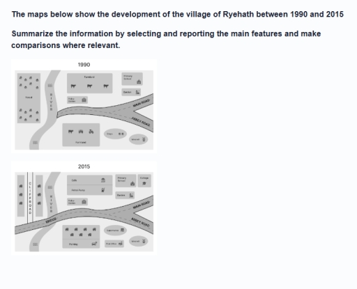
The image displays two comparative maps labeled "1990" and "2015". In the "1990" map, the western section features a "Forest" with 12 tree icons, bounded to the east by a north-south "RIVER". A road originates at the eastern bank of the river and forks into "MAIN ROAD" toward the northeast and "ABBEY ROAD" toward the southeast. North of this road network are "Farmland" containing 3 cattle icons, "Police Station", "Primary School", and "Garden". South of the road are "Farmland" containing 1 cattle and 2 tractor icons, "Shops" depicted as 2 buildings, and an oval-shaped "Market". In the "2015" map, the road is extended westward across the "RIVER" via a "BRIDGE" to join a vertical road labeled "CLIFF ROAD", which is flanked by 6 house icons (3 on the west and 3 on the east). North of the main road, the northern farmland is replaced by "Cafe" and "Petrol Pump", with "Police Station", "Primary School", and "Garden" retained, plus a new "College" east of the primary school. South of the road, the southern farmland is replaced by 7 house icons above a designated "Parking" area with a vehicle icon, the former shops site is occupied by "Supermarket" and "Post Office", and the southeast oval "Market" remains unchanged.
Given the complexity of the image, the above description may not be entirely accurate.
Skyrocket your IELTS band score by 1-2 points in under a month with our premium plan!
Note: Both the topic and the answer were created by one of our users.
The maps illustrates the development that the village of Ryehath went between 1990 and 2015.
Overall, the village shifted from a largely rural settlement to a more developed,residential and commercial community. The forest and farmland have been replaced with housing and services, while river,school and police station remain the same.
In 1990, the westside of the river which was mainly occupied by forest have been replaced by housing facilities with cliffroad running through the center connecting to the main road. The major change is the bridge connecting the two sides of the river, while the main road and abbey road remain unchanged.
The farmland on the north of the road have been replaced with cafe and a petrol pump. The police station, school and garden remains the same with addition of a college beside the school.
The farmland on the south of the road have been replaced with housing and parking area. The shops have been replaced with a supermarket, while a post office is added below the suppermarket. The windwill below the abbey road remaind unchenged,
Word Count: 177
