Our system will evaluate the answer based on this AI-generated description.
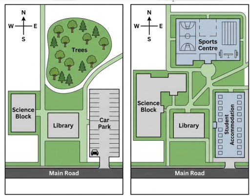
The image presents two comparative site maps oriented by four-point (N, S, E, W) compass roses, both bordered at the bottom by a horizontal "Main Road". In the first map, situated along the north side of Main Road from west to east are a rectangular "Science Block", a central square-shaped "Library", and a vertical rectangular "Car Park" with 35 parking stall markings, one car symbol, and direct road access. North of these lies an enclosed curved green zone labeled "Trees" containing 13 individual tree icons. In the second map, the central "Library" remains unchanged, while the "Science Block" to the west is enlarged into an irregular, multi-cornered polygon extending northeast. In the east, the car park area is occupied by a rectangular "Student Accommodation" building containing 20 small rectangular units (10 along the west wall and 10 along the east wall) with a west-facing entrance. In the north, the wooded area contains a large "Sports Centre" building partitioned into a basketball/court area on the west, an open lobby with a south entrance, a swimming pool with 5 lanes in the northeast, and a weightlifting/gym symbol in the southeast, accessed via an interconnecting pathway system featuring a circular junction.
Given the complexity of the image, the above description may not be entirely accurate.
Skyrocket your IELTS band score by 1-2 points in under a month with our premium plan!
Note: Both the topic and the answer were created by one of our users.
The maps illustrate the current layout of a university campus and the proposed changes after an expansion in five years.
Overall, the campus is projected to become larger and will house numerous state-of-the-art facilities such as the new student accommodation, a new sports centr, and improved transport connections. Every location on the map is expected to undergo some change either in its size or location, with the sole exception of the libary.
At present, the libary is located centrally on the map with a huge car park connected to it on the east which connects to the main road. Similarly, the science block is connected to the libary by a trail but to its west. Looking north, you can spot a vast, green land packed woth trees and bushes.
In the future plan, the library will remain as it is and will not undergo any change in its sixe or location, whereastThe science block is projected to increase in size and expand towards the northeast. A new student accommadation i going to be built in the location of the current car park. Similarly vast, green land packed woth trees and bushes will also be replaced but with a state-of-the-art sports centre in the north.
Word Count: 204
