Our system will evaluate the answer based on this AI-generated description.
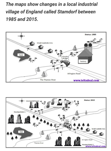
The image presents two maps illustrating the transformation of Stamdorf, an industrial village in England, from 1985 to 2015. In 1985, Stamdorf featured the Thames River flowing horizontally across the map, Arlington Road running parallel above it, a factory situated by the river’s upper bend with access to Arlington Road via a connecting road, four small roadside inns dispersed along Arlington Road, a wooden bridge over the river, and a field positioned on the distant side of Arlington road opposite the factory. In contrast, the 2015 map indicates significant development: the factory remains but now includes two additional road connections to Arlington Road, the small roadside inns have been replaced by housing estates labeled 1 to 3, and the wooden bridge has been upgraded to a solid bridge. Moreover, the field area is reduced considerably and a new road has been constructed connecting the houses to Arlington Road, with two housing estates situated near this new road and another close to the upgraded bridge. The Thames River and Arlington Road maintain their relative positions from the earlier map.
Given the complexity of the image, the above description may not be entirely accurate.
Skyrocket your IELTS band score by 1-2 points in under a month with our premium plan!
Note: Both the topic and the answer were created by one of our users.
The maps illustrate the development of Stamdorf, a local industrial village in England, between 1985 and 2015.
Overall, it can be seen that Stamdorf experienced significant industrial and residential growth, while some features such as the roadside inns and the Thames River remained unchanged, new housing, industrial areas, and infrastructure were introduced.
In 1985, Stamdorf was a relatively small village with a factory located on the east side of the map, connected to the other part of the village by a wooden bridge across the Thames River. Nearby, there were several small roadside inns and a large open field on the western side. Arlington Road ran through the southern part of the village.
By 2015, major changes had taken place. The original factory had expanded into a larger industrial park, and a new staff quarter was built in the north. The wooden bridge was replaced with a steel bridge, showing modernization of transport. Additionally, two large housing estates were established: Housing Estate 1 near the field and Housing Estate 2 along Arlington Road. Despite these developments, the field, the inns, and the Thames River remained intact, although the surroundings became more urbanized.
Word Count: 192
