Our system will evaluate the answer based on this AI-generated description.
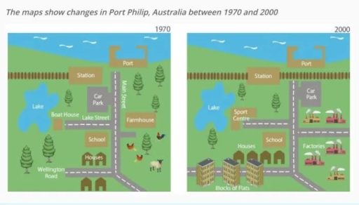
The image presents two maps comparing Port Philip in 1970 and 2000; in 1970, a lake is located centrally left with a boat house to its southeast, adjacent to Lake Street running east-west; a road crosses north-south labeled Wellington Road southeast of the lake; alongside this road laying from top to bottom, port, station, car park, school, and houses; a farm house is situated southeast of the car park; by 2000, the lake remains, though the boat house has been replaced by a sport center; Lake Street and Wellington Road persist; the port and station remain unchanged; car park maintains location; houses extend further northeast and replace school; school replaced by a sport center adjacent to a new extension of houses; original farm house evolves into blocks of flats south of the new extended road; factories emerge northeast near the port, supplanting former undeveloped area.
Given the complexity of the image, the above description may not be entirely accurate.
Skyrocket your IELTS band score by 1-2 points in under a month with our premium plan!
Note: Both the topic and the answer were created by one of our users.
The given maps reveal data about how a town transformed throughout 30-year period, starting from 1970 in Australia.
Overall, it can be clearly seen that the town underwent alternation from boat house into sport centre between 1970 and 2000.Interestingly, car park was transferred to the other side of the road.
Turning to the details, the lake size did not changed; however the number of trees experienced a dramatical drop from 7 to 3, and two streets lost their importance.In addition, in 2000 town was urbanized with 3 aparment buildings.
When it comes to the small houses, four opposing homes were placed on north side.Furthermore, the factories constructed instead of farmhouse in 1970 and 2000 years.Interestingly, the length of wooden fences doubled to the East, respevtively.
Word Count: 125
