Our system will evaluate the answer based on this AI-generated description.
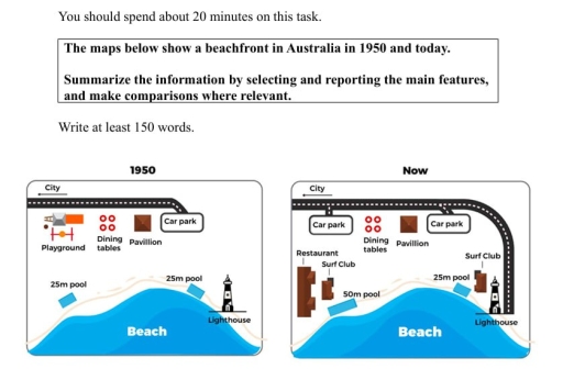
The image displays two maps comparing a beachfront in Australia from 1950 to the present. In 1950, the map shows a city at the top border, followed by a road leading to a car park on the right side. Below the car park are three dining tables aligned vertically, next to which is a pavilion. On the left side of the dining tables, there is a playground. Below the playground, running parallel to the beach, is a 25m pool adjacent to the beach area, which also features a lighthouse at the bottom right corner. In the contemporary map, the city remains at the top, and the road leads to two separate car parks, one near the city and another adjacent to the beach on the right. Centrally, three dining tables are aligned between a restaurant on the left and the unchanged pavilion on the right. Below, a 50m pool stretches parallel to the beach, and a surf club is positioned between the pool and the lighthouse.
Given the complexity of the image, the above description may not be entirely accurate.
Skyrocket your IELTS band score by 1-2 points in under a month with our premium plan!
Note: Both the topic and the answer were created by one of our users.
The two maps compare the beachfront area in Australia between 1950 and the present day.
Overall, the area has undergone significant changes, most notably the addition of a surf club, restaurant and the removal of the playground.
In the east-west
In part of the area, a surf club has been added, while in the western part, a restaurant has been introduced. Additionally, the pool area has undergone changes, including an increase in the size of the pool.
Meanwhile, in the northwest corner, the playground has been removed and a car park now occupies that space, suggesting a shift towards accommodating more vehicles rather than children’s play areas.
Word Count: 107