Our system will evaluate the answer based on this AI-generated description.
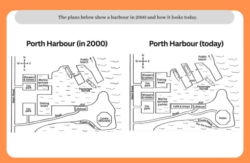
The image displays two comparative layout maps titled "Porth Harbour (in 2000)" and "Porth Harbour (today)", both showing a compass rose indicating North (N), South (S), East (E), and West (W). In "Porth Harbour (in 2000)", the western perimeter along "Main Road" features an upper block with "Showers & toilets" and "Car park" adjacent to an inlet marked "Marina (private yachts)", and a lower "Car park" next to "Fishing boats"; an eastward-extending "Road" connects to "Lifeboat", a southern shoreline "Public beach", and an octagonal structure labelled "Castle (disused)"; harbor waters show a single "Dock" with one vessel, a boat marked "Passenger ferries", and an arrow pointing northeast to "Public beach". In "Porth Harbour (today)", the western "Main Road" connects to an upper "Showers & toilets" and "Car park" beside relocated "Fishing boats", above a second "Showers & toilets" and "Car park" next to relocated "Marina (private yachts)"; along "Road" sits added "Café & shops" beside "Lifeboat", terminating at an octagonal "Hotel" bordered by "Private beach (for the hotel)"; the water area features two parallel piers labelled "Dock" berthing two vessels, alongside a boat labelled "Passenger ferries" and an arrow directing northeast toward "Public beach".
Given the complexity of the image, the above description may not be entirely accurate.
Skyrocket your IELTS band score by 1-2 points in under a month with our premium plan!
Note: Both the topic and the answer were created by one of our users.
The maps illustrate the changes that have taken place in Porth Harbour between 200 and the present day.
Overall, the harbour undergo considerable development, particularly about tourism. The most notable changes include the construction of a hotel and the introduction of cafes and shops.
In 2000, there was the castle in the south-east, which was not usable. This castle replaced by the hotel and there is a way for reaching this hotel from main road and lifeboat. In the first map, the beach for public usage but now it belongs to the hotel and private. In the west, Marina which is for private yachts, changes place with fishing boats. It can also observe that showers and toilets is doubled now. In 2000, there was only one dock and two passenger ferries can park both sides of dock. Today, the number if docks has doubled, and they can now accommodate three ferries. In addition, public beach does not change over the period.
Word Count: 161
