Our system will evaluate the answer based on this AI-generated description.
The image shows two maps labeled "Westley in 1815" and "Westley Now." The 1815 map depicts a river flowing top to bottom with a bridge, a road labeled "London Road" intersecting the bridge horizontally, "The Green Man Inn" north of the bridge, and "The Coach and Horses Inn" south of it. There are labeled areas "Lord Harris House," "Lemon Woods," and "Tiverton Village" east of the river, with "Market Square" and "Houses" southwest of it, and "Fields" on the western edge. The current map shows a railway replacing the river, "Sports Centre" and "Museum" where "Lemon Woods" was, "Leisure Centre" and "Lake Leisure" where "Tiverton Village" was, "Market Square" maintained but surrounded by "Shopping Centre," and "Cinema" south of it, and "Business and Residential Area" west where "Fields" were. The bridge and both inns are gone, with a labeled "The Red Lion" inn northeast of "Market Square."
Given the complexity of the image, the above description may not be entirely accurate.
Skyrocket your IELTS band score by 1-2 points in under a month with our premium plan!
Note: Both the topic and the answer were created by one of our users.
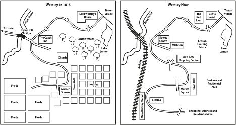
The two diagrams display the differences that happened in the town of Westley since the year 1815.
Overall, the town itself received a lot of changes, like the modernised way of transportation in and out of the town. There are also several infrastructure that were built and some are converted into one with a different use, which sacrificed a few natural features of the town.
In 1815, the way into town was the Twine Toll Bridge that was over the River Twine, but this was replaced with a railway that stops in the Main Railway Station. Near the Tinton Village there is a residence named Lord Westley’s House but it was reconstructed into two buildings which are Lenton Hotel and The Red Lion. Furthermore, the Sports Centre and Museum replaced where The Coach Inn used to reside.
The trees were chopped-down and the fields were cleared, to allow a Lenton Housing Estate and the Railway to be built, respectively. Additionally, the newly expanded roads lead to a Cinema, Shopping, Business and Residential Area. Despite this, some places were untouched , including the Market Square, Town Hall, and Lake Tenton.
Word Count: 189