Our system will evaluate the answer based on this AI-generated description.
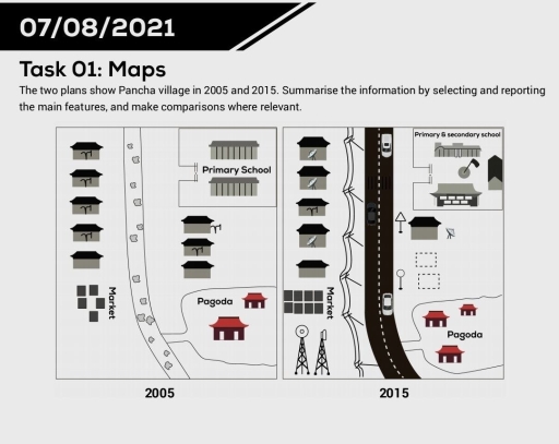
The image presents two comparative site plans labeled 2005 and 2015. In 2005, a tree-lined unpaved pathway curves vertically through the center. To the west of the path, a vertical column of 5 houses stands above a "Market" composed of 5 square stalls. To the east of the path, the layout features a fenced "Primary School" compound with 2 long buildings at the top, a vertical column of 3 houses in the center, and a "Pagoda" area with 2 pagoda buildings at the bottom southeast. In 2015, the central path is replaced by a wide, paved, marked two-lane road carrying 3 cars, bordered on the west by a zigzag fence line. To the far west, the vertical row still contains 5 houses (3 equipped with satellite dishes), the "Market" expands to 8 square stalls (arranged in two rows of 4), and 2 communication transmission towers stand at the southwest corner. East of the road, the educational area is labeled "Primary & secondary school" with modified/expanded buildings and a central flagpole, situated north of a single house equipped with a satellite dish, adjacent to 2 road signs and 2 dashed rectangular footprints, while the southeast "Pagoda" area features 3 pagoda buildings.
Given the complexity of the image, the above description may not be entirely accurate.
Skyrocket your IELTS band score by 1-2 points in under a month with our premium plan!
Note: Both the topic and the answer were created by one of our users.
The two maps illustrate the changes took place in the Pancha between 2005 and 2015. Overall, the area became more accessible as well as residential mainly due to the construction of a new road, and the extension of houses. While, most part of the area changed ove the period shown, the eastern corner of the map almost remained unchanged, with the exception of a reduction to the houses and the addition of a few road signs.
In 2005, the unused street running through a village was situated in the center of the map with several houses to the west and east, and the top-right edge of which was a Primary school. In the southeast, there used to be a Pagoda and in front of it were disorderly built shops.
In 2015, the old street was knocked down to make a way for a newly-built road. Modern television aerials were installed in the houses to the west. The secondary school was constructed in the area where also consisted of Primary school. In the southeast, the third building of Pagoda was constructed. The disordered shops to the southwest were erected properly, next to it two aerials were introduced.
Word Count: 196
