Ancient Village at Bidcuster - IELTS Listening Answers & Explanations
From Cambridge IELTS 20 Academic Listening Test 3 · Part 2 · Questions 11–20
Audio
Questions
Questions 11–16 Multiple Choice (One Answer)
Choose the correct letter, A, B or C
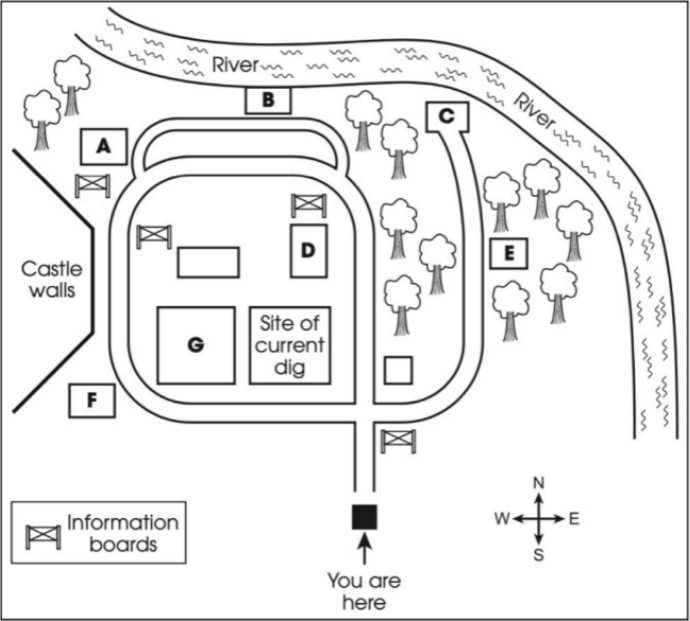
Questions 17–20 Map Labeling
Label the map below. Drag the correct letter, A–G, next to Questions
Answers & Explanations Summary
| # | Answer | Evidence | Explanation |
|---|---|---|---|
| Q11 | B | but I was asked to join the project by NHA, a charity which sets up projects like this up and down the country | Excerpt/Transcript Explanation: The transcript says that Hayden was asked to join the project by NHA, a charity. This means the charity is helping to start and organize the project. Answer Explanation: The answer is B, which means a national charity helped to start the community project. Reason For Correctness: The correct answer is B because the archaeologist, Hayden, mentioned that the project was set up by NHA, which is a charity that organizes projects like this across the country. This shows that the charity was responsible for starting the project. |
| Q12 | A | a walker found it on the ground after a rainstorm washed away some of the earth and sand | Excerpt/Transcript Explanation: The transcript says that someone walking found the coin on the ground. This happened because the rain made the dirt and sand lighter, so the coin was easier to see. Answer Explanation: The answer means that strong rain made the soil lighter, which allowed the gold coin to be seen on the ground. Reason For Correctness: The correct answer is A because the transcript says that a walker found the gold coin on the ground after a rainstorm washed away some of the earth and sand. This means that the rain helped to show the coin by removing the soil above it. |
| Q13 | A | Just by chance, the team found some old maps and documents in our library, which showed 500-year-old drawings of ruined buildings on the grassy area between the outer stone walls of the castle and the river | Excerpt/Transcript Explanation: The transcript says that the archaeologists found old maps and documents in their library. These maps showed drawings of buildings that were 500 years old on the land near the castle. This is important because it helped them understand that there was an ancient village. Answer Explanation: The answer is A, which means the archaeologists found some old records that showed there was an ancient village. Reason For Correctness: The correct answer is A because Peter Swift, an amateur historian, contacted the archaeologists after a gold coin was found. He believed there had been an ancient village on the site. The team later found old maps and documents that showed drawings of ruined buildings. This information led them to think there really was a village there. |
| Q14 | C | Normally you'd expect to find brooches and other jewellery, but we're still waiting to uncover any such items | Excerpt/Transcript Explanation: The transcript means that usually, archaeologists find small beautiful things like brooches or other types of jewellery, but here they have not found any yet, indicating they still want to find some. Answer Explanation: The answer is C, which means they are hoping to find pieces of jewellery. Reason For Correctness: The correct answer is C because in the transcript, it says that normally you would expect to find jewellery, but they are still waiting to uncover any such items. This shows that they are hoping to find pieces of jewellery. |
| Q15 | B | we've also found evidence of human activity on the other side of the river. No other houses or huts so far, but we can see the borders of an ancient field system | Excerpt/Transcript Explanation: The transcript says that there is proof of people living on the other side of the river, but they did not find any houses. Instead, they could see where the old fields used to be. Answer Explanation: The answer is B, which means that the outline of fields was found on the other side of the river to the castle. Reason For Correctness: The correct answer is B because the archaeologist mentioned that they found evidence of human activity on the other side of the river. They stated that they could see the borders of an ancient field system, which matches answer B. This shows that there were not large buildings or huts, but fields instead. |
| Q16 | C | In the meantime, we're putting on a series of guided tours for school groups this autumn | Excerpt/Transcript Explanation: The transcript says they will have tours for school groups in the fall. This means they are planning to let school children visit and learn about the site. Answer Explanation: The answer means they will get ready to show the site to school groups. Reason For Correctness: The correct answer is 'Start to organise school visits' because the archaeologists mentioned they will have guided tours for school groups this autumn after their work ends this summer. This shows that they plan to arrange visits for schools. |
| Q17 | B | To reach the bridge, take the main path ahead of you, go straight on, and keep going till the path bends to the left. You’ll see a smaller track leading off to the right. | Excerpt/Transcript Explanation: The transcript explains how to get to the bridge foundations. It says to go straight ahead on the main path, then continue until the path turns left, and then look for a smaller path to the right. Answer Explanation: The answer 'B' means that the letter B is the location of the bridge foundations on the map. Reason For Correctness: The correct answer is 'B' because the transcript gives clear directions to find the bridge. It mentions going straight on the main path and then looking for a track to the right. This means that the bridge foundations are marked with the letter B on the map. |
| Q18 | A | You might be interested to see the rubbish pit. This is very near the castle walls in the north-west corner of the site | Excerpt/Transcript Explanation: The transcript says the rubbish pit is close to the castle walls in the north-west corner. This means it is located at point A on the map. Answer Explanation: The answer is A. This means that the rubbish pit is located at place A on the map. Reason For Correctness: The correct answer is A because the transcript explains that the rubbish pit is located near the castle walls in the north-west corner of the site. This means it is marked as A on the map. |
| Q19 | G | It is the largest structure in the central area of the site next to the current excavation area | Excerpt/Transcript Explanation: The transcript says that this building is the biggest one in the middle of the site, near where they are digging now. Answer Explanation: The answer is G. This means that G is the correct label for the meeting hall on the map. Reason For Correctness: The correct answer is G because the transcript explains that the meeting hall is an important building at the site. It mentions that this hall had two rows of post holes and was the largest structure in the central area, close to where they are currently excavating. This indicates that the meeting hall is marked as G on the map. |
| Q20 | E | To get there from here, you turn right at the first information board you come to and follow the path into the trees. Before you come out of the trees, you'll see it on your right | Excerpt/Transcript Explanation: The transcript explains how to find the fish pond. You need to turn right at the first sign and go into the trees. The pond will be on your right side before you leave the trees. Answer Explanation: The answer is E. This means that the fish pond is marked with the letter E on the map. Reason For Correctness: The correct answer is E because the transcript talks about where the fish pond is located. It says that to find the fish pond, you need to turn right at the first information board and follow the path into the trees. The pond is on your right before you come out of the trees. |
Transcript
Hello, I’m Hayden. I’m one of the archaeologists investigating the site here at Bidcuster. This is the third summer for this community project, and most of the people digging here are volunteers. I’m a full-time archaeologist for the town council, but I was asked to join the project by NHA, a charity which sets up projects like this up and down the country. As you can see, we’re next to Bidcaster Castle, which is great because the owners let us use their facilities. So, how did we get to where we are today?
Many archaeology projects happen when an ancient object is found, and in our case that object was a gold coin. Coins are often found by people using metal detectors to look for things buried in the ground or coins are uncovered when wild animals like rabbits have been digging tunnels. Here, a walker found it on the ground after a rainstorm washed away some of the earth and sand. When the story of the gold coin hit the news, Peter Swift, an amateur historian, contacted me to say he believed there had been a village on this site, centuries before the castle was built. Just by chance, the team found some old maps and documents in our library, which showed 500-year-old drawings of ruined buildings on the grassy area between the outer stone walls of the castle and the river. We knew then we were onto something. Over the three summers the team has been here, we’ve found the remains of several buildings, and more broken pots than you can count. Normally you’d expect to find brooches and other jewellery, but we’re still waiting to uncover any such items. The people who once lived here were skilled at making tools from animal bones, as you’ll see when you visit the exhibition. Besides the discovery of the village, we’ve also found evidence of human activity on the other side of the river. No other houses or huts so far, but we can see the borders of an ancient field system. At one point we found a long wall and thought it was an ancient palace, but it turned out to be a modern wall. This summer’s work will end soon, but we’ll be back next summer. In the meantime, we’re putting on a series of guided tours for school groups this autumn. Oh, and maybe you saw the TV documentary about our project. That suggests the objects we’ve found are going to the town’s museum, but we don’t know that for sure yet.
----------------------
When you enter the site, please make sure you keep to the paths at all times. There are a few other things, the highlights of the site if you like, that I want to mention. Take a look at the map. Our present location is marked at the bottom. This year, we’ve identified the foundations of an ancient bridge, and it’s really exciting today because a team of divers are in the river searching for lost objects. To reach the bridge, take the main path ahead of you, go straight on, and keep going till the path bends to the left. You’ll see a smaller track leading off to the right. Follow that to take you to the river, where the divers are. You might be interested to see the rubbish pit. This is very near the castle walls in the north-west corner of the site. It actually dates to the time of the castle and not the ancient village. We found oyster shells and fish bones, and we assumed they were thrown from the castle kitchen above. One area we excavated in the first summer uncovered the site of a meeting hall. We knew it was an important building because it had two rows of post holes, deep enough to support a large roof. It is the largest structure in the central area of the site next to the current excavation area. Last year we discovered a fish pond in the ancient village. Normally these were beside a river. The pond here is further away, but it’s possible the river has moved slightly. Anyway, to get there from here, you turn right at the first information board you come to and follow the path into the trees. Before you come out of the trees, you’ll see it on your right. If you reach the river, you’ve gone too far. So, does anyone have…