Our system will evaluate the answer based on this AI-generated description.
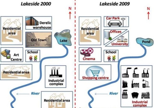
The image shows two side-by-side maps labeled "Lakeside 2000" and "Lakeside 2009" with a compass indicating North at the top of each map. In "Lakeside 2000," the map features a lake with an "Old Town" to its left, a "Derelict warehouse" above the lake, a "Residential area" to the right of the lake and above the "Old Town," an "Art Centre" below the "Old Town," a "School" below the "Art Centre," a "Residential area" below the "School," an "Industrial complex" to the right of the "Residential area" and below the lake, and another "Residential area" below the "Industrial complex," all areas separated by a wavy "River" running from the bottom left to top right of the map. In "Lakeside 2009," the same wavy "River" runs through the map, the previous "Lake" is now a "Pond," the "Old Town" and "Derelict warehouse" have been replaced by "University" and "Offices" respectively, the "Residential area" to the right of the "Pond" remains, the "School" is in the same position but now has a "Cinema" above it, the "Art Centre" has been replaced by a "Shopping centre," the "Residential area" below the "School" remains, the "Industrial complex" remains in the same position, and the "Residential area" below the "Industrial complex" also remains.
Given the complexity of the image, the above description may not be entirely accurate.
Skyrocket your IELTS band score by 1-2 points in under a month with our premium plan!
Note: Both the topic and the answer were created by one of our users.
The images depict the transformation of Lakeside from 2000 to 2009. Overall, the town underwent a significant modernization process, resulting in a substantial shift from traditional infrastructure to more contemporary amenities. Notable changes include the conversion of older town facilities into modern equivalents, the demolition of a residential area to accommodate industrial expansion, and the shrinking of the lake into a pond. However, the school and a northern residential area remained untouched.
In 2000, Lakeside was bisected by a stream originating from a lake in the north. On the left side of the stream, two residential areas were separated by an art center and a school. Adjacent to the northern residential zone, residents had access to a derelict warehouse and an old town center. On the right side of the stream, a southern housing area and an industrial complex occupied the land.
By 2009, both sides of the stream had experienced significant alterations along with twice less water bank in the pond than the prior lake. On the left side, the central residential zone had been replaced by a modern shopping center. The derelict warehouse was demolished to create a parking lot, while the old town was replaced by offices and a university. The art center was transformed into a cinema, while the school and northern residential area remained unchanged. On the right side of the stream, the industrial complex had expanded significantly, swallowing the southern residential area.
Word Count: 238
