Our system will evaluate the answer based on this AI-generated description.
The image displays a map of Garlsdon, population 65,000, featuring two potential supermarket sites, labeled S1 and S2. S1 is positioned on the western edge within the urban zone, adjacent to the main road needed to reach Hindon, with the town situated 12 km away and a population of 10,000. S2 lies on the southern boundary of the town center, within the non-traffic zone. Branston, 16 km to the southwest, has a population of 15,000, while Cransdon, located 25 km to the southeast, has a population of 29,000. Main roads create a network connecting these areas. A railway system traverses Garlsdon from east to west, passing through the town center but missing S1 by a radius that incorporates countryside, housing, and industry. The town center is encased in a non-traffic zone near industry areas, while housing primarily envelopes the northern ease of Garlsdon, merging into the surrounding countryside.
Given the complexity of the image, the above description may not be entirely accurate.
Skyrocket your IELTS band score by 1-2 points in under a month with our premium plan!
Note: Both the topic and the answer were created by one of our users.
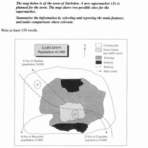
The map illustrates two possible locations of a new supermarket that is planned for the town of Garlsdon which has a population of 65,000.
Overall, the first site is less accessible by citizens of the other 2 cities nearly Garldson: Brandson and Crandson. The second is very easy to reach from all towns, including the third, Hindon.
The first location considered is in the north west, outside of housing zone, specifically in the countryside. It is located between railway on the left and main road on the right, in particular is directly linked to Hindon with either, while with Crandson by only train system but with higher distance. People of Brandson have to necessarily use the main roads to arrive in Garldson centre and then the other main roads or the railway.
The other option is in town centre, which is a no traffic zone. It lies between industrial zones, on the north and south sides. Indeed, the railway pass through all the centre, especially would be very close to the supermarket. All three cities have a direct access without change transport modes.
Word Count: 183
