Our system will evaluate the answer based on this AI-generated description.
The image contains two maps labeled "1960" and "Now," both oriented with north indicated at the top. In 1960, the map shows a harbour at the northern edge, African animals and Australian animals on the western side, a birds section and a chimpanzees section in the central area, a seal show near the harbor, a picnic area in the northeast corner, and a gift shop between the chimpanzees and the picnic area. In the current map labeled "Now," a harbour and a ferry are at the northern edge, with an entrance to the southwest, areas labeled wild animals and Australian animals on the western side, African animals in the central region, a seal show near the harbour, a gift shop near the African animals, a cable car route extending from near the entrance to the picnic area in the northeastern corner. The picnic area has moved eastward compared to the 1960 map.
Given the complexity of the image, the above description may not be entirely accurate.
Skyrocket your IELTS band score by 1-2 points in under a month with our premium plan!
Note: Both the topic and the answer were created by one of our users.
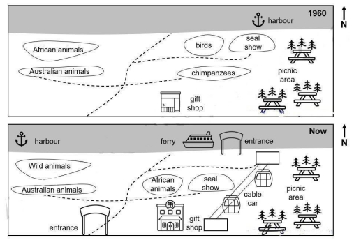
The map below illustraters some changes have been made to an australian zoo between 1960 and the present plans.
Overall,a number of changes have been made to a zoo in australia.These include some changes such as cabel car,ferry and new entrance.
Looking at the maps in more detail,the harbour was located in the northeast side, which is relocated in the current plans in the northwest corner also newly added ferry and a new entrance. To the west of the map this road were the african animals and directly below australian animals,african animals is replaced and transferred in the middle of the map also wild animals in the present plans.Moreover,australian animals road was connected with champanzees in previous plans in contrast,champanzees rebuild by seal show.
Word Count: 124