Our system will evaluate the answer based on this AI-generated description.
The image shows two maps of Templeton in 1990 and 2005, illustrating transformations at the seaside resort. In 1990, the resort had 12 individual houses scattered across the map, a sequence of trees and a pond along a secondary road in the north, one school adjacent to the pond, a hospital at the northeast corner with a nearby parking area and railway station. In 2005, the houses are in two grouped residential blocks, one block of 4 houses occupies the northwest and another set of 8 occupies the southeast corner alongside the railway station and railway line extending further along the coast. The school and hospital remain, but the southern area, where three houses once stood, now features a new supermarket adjacent to an added factory. A ferry service is visible on the southern coast, and an airport appears north of the newly extended railway. The pond and some trees were removed to accommodate the expansions.
Given the complexity of the image, the above description may not be entirely accurate.
Skyrocket your IELTS band score by 1-2 points in under a month with our premium plan!
Note: Both the topic and the answer were created by one of our users.
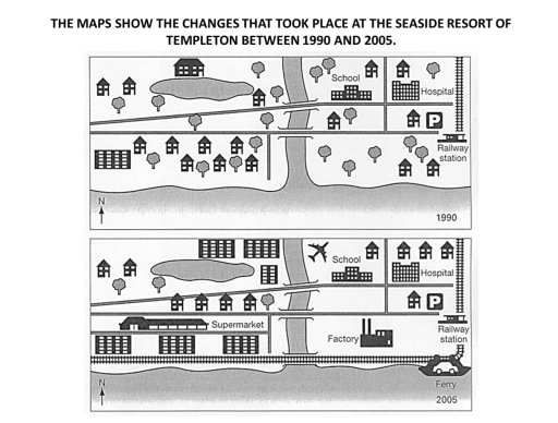
The map compares the modification of the seaside resort of tempelton that took place in the period of 1990 and 2005.
Overall, in 1990, The houses on the bottom left were demolished and supermarket was built in 2005. Factory and Ferry was also developed at the right side of map below the railway station.
In 1990, There were just houses in the north west and by 2005, A supermarket was constructed and railway track expanded. By 2025, school and hospital was remained at the same position with a parking just below the hospital.
Railway station was located at the right with an entrance to the parking. Trees and Houses on the right was knocked down and Factory was developed to the left of railway station by 2025. A ferry was also contructed near the railway track in 2025.
Word Count: 138