🔥 Today Only: Save 30% on Premium — Offer Ends Soon! - Upgrade Now!
Map

Band 5+: The maps below describe a town in the Atlantic Ocean affected by a volcanic eruption in 1706. Summarise the information by selecting and reporting the main features and make comparisons where relevant.

Image for topic: The maps below describe a town in the Atlantic Ocean affected by a volcanic eruption in 1706. Summarise the information by selecting and reporting the main features and make comparisons where relevant.
Our system will evaluate the answer based on this AI-generated description.
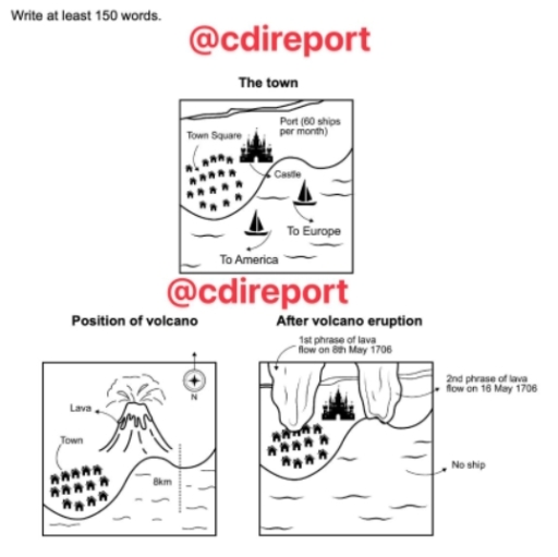
The image presents three maps illustrating a settlement and a volcanic event: 'The town', 'Position of volcano', and 'After volcano eruption'. In 'The town', the coastal map depicts a 'Town Square' surrounded by small dwelling icons, an adjacent 'Castle', and a coastline labeled 'Port (60 ships per month)', alongside two ships in the sea labeled with routes 'To Europe' and 'To America'. In 'Position of volcano', oriented with a north arrow ('N'), an erupting peak labeled 'Lava' is located inland, alongside the 'Town' icons and a coastal distance indicator marked '8km'. In 'After volcano eruption', the landscape shows two separate flow boundaries designated as '1st phrase of lava flow on 8th May 1706' adjacent to the town houses and castle, and '2nd phrase of lava flow on 16 May 1706' covering the previous port area into the sea, where the water is marked 'No ship'.
Given the complexity of the image, the above description may not be entirely accurate.
Note: Both the topic and the answer were created by one of our users.

Three maps illustrates a small city in the Atlantic ocean which was witnessed a volcano catastrophe in 1706.

Overall, it is clear to see that there are 3 maps, which describe the town before volcano, position of volcano and town after eruption.

It is worth noting that before cataclysm, there were a town square near to the enormous castle. Port was located on the north of the map, which was held 60 ships per month. On the south of the map, there are a lot of ships that were shipped to America or to Europe.The position of volcano wasn’t good at all, it was located near to the town and lava could hit them very fast.

After dramatic cataclysm in the 8th of May, lava flew some houses in the town, but after the second phase in the 16th of May, it covered the whole port, so all ships had gone.

Word Count: 151

Answers On The Same Topic:

The maps below describe a town in the Atlantic Ocean affected by a volcanic eruption in 1706. Summarise the information by selecting and reporting the main features and make comparisons where relevant.

The pictures demontrate impacts of a volcanic eruption which happened in 1706 on a region situated in the Atlantic Ocean. As can be seen from the maps, the disaster had a detrimental influence on the town’s port activities. Looking at the first map, there was a castle located near the seashore, with residential houses and […]

See All

Other Topics:

The maps below show the changes in the town of Dalton between 1815 and 2015.

The given maps illustrate the transformation of Dalton Hall from a predominated rural area in 1815 into a modern, urbanized area by 2015. From a comprehensive point of view, the entire Dalton Hall in 1815 was dominated by nature and agriculture; while there was minimal human settlement and limited traffic systems. The area underwent significant […]

The maps below show the development of Shelby Village between 1970 and 2010. Summarise the information by selecting and reporting the main features and make comparisons where relevant.

The maps illustrate the recontruction of Shelby village from 1970 to 2010.Overall ,Shelby village was mostly cover by vast forest and large area of field with only few number of resort. Whereas after following few years proper roads ,offices and new housing were build while completly eliminating agriculture land and deforestation.In additional more resorts were […]

the plans below shows a public park when it first opened in 1920 and the same parrk today. summarise the information by selecting and reporting the main features, and make comparisons where relevant.

The plans give information about the first openong of Grange park in 1920 and the same park in current day. Overall, it is clearly observed that some facilities got removed. There are several features which got established in today’s location. Some places remain the same and saw no change, while other relocated and moved to […]

The plan below show the layout of Dale Hall Conference center when it was built in 2010 and as planned for 2025.

The diagram illustrates how the layout of the Dale Hall Conference center will change in 2025 compared to that in 2010. Overall, it is clear that more infrastructure will be built in 2025, including areas for daily life needs and also places for entertainment and work. Back then in 2010, most of the areas in […]

The diagrams below show the changes that have taken place in a sports centre from 2007 to the present day.

This diagram presents the changes that happened to a university sports centre from 2007 to present-day.This text will walk you through the changes that happened throughout the years. In 2007,the football pitch was solitary and not surrounded by anything;however,now it has a running track around it that was not there before.The football pitch also became […]

See All
We have detected unusual activity on your device.
Please verify your identity to continue.
Note: This verification step won't sign you in. If you have a premium account, please log in to access the service as usual.
Google/Gmail Verification
Or verify using Email/Code
We've sent a verification code to:
youremail@gmail.com (Not your email?)
Enter it below to complete the verification process.
Ensure your email address is correct, your inbox is not full, and you check your spam folder. If no email arrives, consider using an alternative email.
You will need a Premium plan to perform your action!
Note: If you already have a premium account, please log in to access our services as usual.

Plans & Pricing

Our mission is to make quality education accessible for everyone.
However, to keep our hardworking team running and this service alive, we genuinely need your support!
By opting for a premium plan, not only do you sustain us in achieving the mission, but you also unlock advanced features to enrich your learning experience.

Free

For learners who aren't pressed for time

What's included on Free
100+ Cambridge IELTS Tests
Instant IELTS Writing Task 1 & 2 Evaluation (2 times/month)
Instant IELTS Speaking Part 1, 2, & 3 Evaluation (2 times/month)
Instant IELTS Writing Task 1 & 2 Essay Generator (2 times/month)
500+ Dictation & Shadowing Exercises
100+ Pronunciation Exercises
Flashcards
Other Advanced Tools

Premium

For those serious about advancing their English proficiency, and for IELTS candidates aspiring to boost their band score by 1-2 points (especially in writing & speaking) in just 30 days or less

What's included on Premium
Save Your IELTS Test Progress & Analyze Mistakes By Question Type
Save Your Own Flashcard Sets & Use Them On Any Device
Unlock All Courses, IELTS Tests, Section & Part Practice
Unlimited AI Conversations
Unlimited AI Writing Enhancement Exercises
Unlimited IELTS Writing Task 1 & 2 Evaluation
Unlimited IELTS Speaking Part 1, 2, & 3 Evaluation
Checked Answers Will Not Be Published
Unlimited IELTS Writing Task 1 & 2 Essay Generator
Unlimited IELTS Speaking Part 1, 2, & 3 Sample Generator
Unlimited Usage Of Advanced Tools & AI Features
Priority Support within 24h (12-month plan only)

Due to the nature of our service and the provided free trials, payments are non-refundable.