Our system will evaluate the answer based on this AI-generated description.
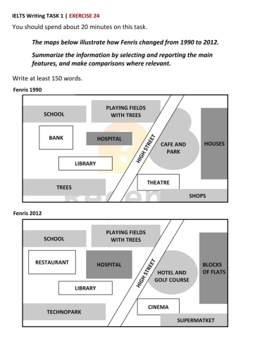
The image contains two maps depicting Fenris from 1990 and 2012. In 1990, the map shows a school in the northwest corner, adjacent to playing fields with trees and a bank to the southeast of the school. A hospital lies directly east of the bank, with a library below the bank. Continuing south, there are trees bordering the southern edge. To the east of the hospital, a cafe and park is located, surrounded by houses further to the east. The map also notes a main street running vertically with a theater situated to the east of the cafe, and shops positioned below the theater. In 2012, alterations present a school remaining in the northwest, with playing fields with trees directly east. A restaurant replaces the previous location of the bank. The hospital remains at its location while the library stays below the former bank. Below the library, a technopark is noted. Further east, a cinema and supermarket now occupy the spaces of the previous theater and cafes, and a hotel and golf course appear east of the hospital, with new blocks of flats replacing the houses.
Given the complexity of the image, the above description may not be entirely accurate.
Skyrocket your IELTS band score by 1-2 points in under a month with our premium plan!
Note: Both the topic and the answer were created by one of our users.
The maps show how Fenris changed among 22 years.
School,library and hospital has not changed their places. However, hospital begun more bigger in 2012 than 1990. Also,it was bank next to the hospital in 1990. Therefore, instead of bank there is restaurant in 2012.
Moreover near the night street were cafe and park but after 22 years they became hotel and golf course. The biggest difference are houses. Among 22 years simple houses became a huge blocks of flat.
For people who live there Fenris has enormous supermarket under the flats.
In conclusion,over 22 years Fenris had enormous success and difference.
Word Count: 101