Our system will evaluate the answer based on this AI-generated description.
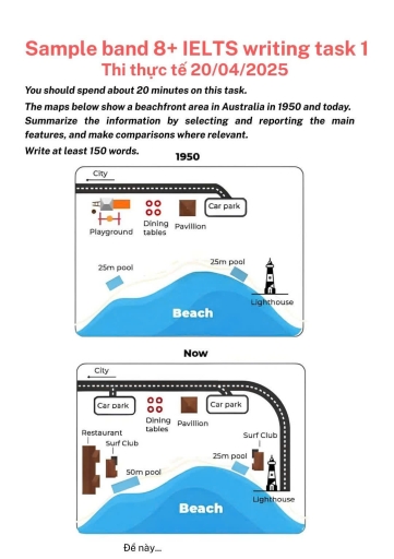
The image shows a map with two snapshots of a beachfront area dated as 1950 and now. In 1950, the map includes features such as a city in the top left corner, a car park positioned to the northeast, dining tables situated in the center, a pavilion slightly to the south, a lighthouse near the oceanfront to the southeast corner, and a playground adjacent to the dining tables to the northwest. Additionally, a 25-meter swimming pool is placed north-central, right before the beach. In the current map, it shows a city in the top left corner, two car parks – one in the north-central adjacent area and one near the pavilion, a restaurant in the northwestern area beside dining tables, a pavilion in the same center position, a 50-meter swimming pool in the north-central area, a surf club positioned near the southern beachfront, and a lighthouse south-east along the oceanfront.
Given the complexity of the image, the above description may not be entirely accurate.
Skyrocket your IELTS band score by 1-2 points in under a month with our premium plan!
Note: Both the topic and the answer were created by one of our users.
The provided map illustrated that how beachfront area has redeveloped between 1950 to present in Australia
Overall, it is evident that the layout has drastic modernization over the time. Particularly, several recreational area ware introduced, while Lighthouse remained largely unchanged.
In 1950, there was a playground on top left corner and now it’s replaced by car park area. Moreover in past the street ended in a car park but in present, the street extended direct to the Lighthouse.
There is some new building introduced that is surf club, and also a new restaurant ware constructed in west side . Some building are remained untouched including dining table, pavilion, top right car park . There was two 25m pool east and west side . In addition the pool from left side ware expended 25m to 50m .
Word Count: 136
