Our system will evaluate the answer based on this AI-generated description.
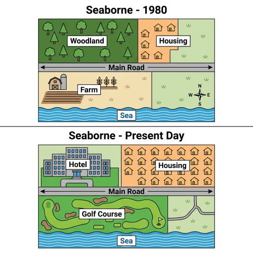
The image presents two map diagrams titled "Seaborne - 1980" and "Seaborne - Present Day". In "Seaborne - 1980", a central horizontal double-arrowed "Main Road" spans above the southern "Sea". Below the Main Road, the western section contains a "Farm" with farm structures, crops, and plowed field, while the eastern section is open land featuring a compass rose marked with directional points "N", "S", "E", and "W". Above the Main Road, the western section contains "Woodland" filled with trees, and the eastern section features a "Housing" area containing 6 house icons alongside open land. In "Seaborne - Present Day", the central horizontal "Main Road" and southern "Sea" occupy the same locations. Below the Main Road, the western section contains a "Golf Course" with sand traps and a flag, while the eastern section displays open land with paths. Above the Main Road, the western section contains a multi-story "Hotel", and the eastern section contains a "Housing" area with 21 house icons.
Given the complexity of the image, the above description may not be entirely accurate.
Skyrocket your IELTS band score by 1-2 points in under a month with our premium plan!
Note: Both the topic and the answer were created by one of our users.
The two maps illustrate the changes the occured in the coastal town of Seaborn since 1980 to the present day.
Overall, it can be observed that Seaborn has been completely transformed from a small rural settlement into a built up residential town. The woodland has been removed and Hotel has been constructed. Houses has been expanded substantially and golf course has been introduced.
In 1980, the woodland that covered the north-west side in 1980 has been demolished and a new hotel has been constructed. Furthermore, the small cluster of the houses that occupied the north-east side has been greatly expanded with many more homes filling the same area.
Additionally, in the south side of the main road, changes are also significant. The farmland that occupied the south-west side has been removed and a wide golf course has been constructed. The free space which was near the farm in 1980, a road has been constructed over it to connect the main road and golf course, completing the transformation.
Word Count: 167
