Our system will evaluate the answer based on this AI-generated description.
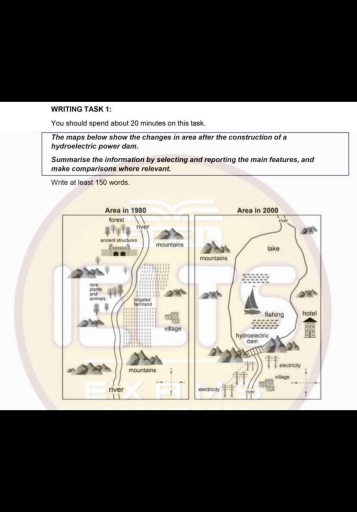
The image depicts two maps comparing an area in 1980 and in 2000. In 1980, the area features a river flowing north to south, forests in the northwest, mountains in the north-central, farmland spread east and west, a village along the south stretch of the river, mountains in the southeast, and a road running parallel to the river from north to south. By 2000, the river transforms into a lake covering the central region, a hydroelectric dam is constructed across the southern part of the river, and additional electricity lines run east-west. The lake facilitates fishing and boating activities, and a large hotel is situated on the southeastern shore. The western area previously occupied by farmland is now converted into a recreational space, and former roads and villages are submerged or replaced by new infrastructure related to the dam and lake.
Given the complexity of the image, the above description may not be entirely accurate.
Skyrocket your IELTS band score by 1-2 points in under a month with our premium plan!
Note: Both the topic and the answer were created by one of our users.
Both maps display an area, before and after there was constructed a hydroelectric power dam.
Overall, over the period, the construction of a dam completely transformed the area with the addition of lake and hotel. Also, irrigated farmland was removed and replaced with a possibility of go fishing.
One of the most noticeable changes is that forests and rare plants were cut down as well as animals disappeared. Moreover, ancient structures in the north of the area were demolished. Coasts of the river in the south are now connected by the bridge.
The village located in the east of the area was replaced with a hotel and relocated to the south.
Word Count: 111