Our system will evaluate the answer based on this AI-generated description.
The image presents two maps displaying the town layout of Newport in 1980 and 2010, showing several changes. In 1980, the town had a school north of a main horizontal road, eastward from a hospital with a parking lot, and a lake to the far northeast surrounded by trees. There were three houses along the north-south road intersecting the main road. A railway station was situated south of the main road. By 2010, the school location remained unchanged while a new shopping centre appeared directly to the south of the school. The hospital and its parking lot persisted in the same spot. The former houses were replaced by a sports ground, university, and apartments. A factory emerged to the far east of the apartments. The railway station remained unchanged. The maps also indicate the removal or reduction of trees across the town by 2010, in areas surrounding these new developments.
Given the complexity of the image, the above description may not be entirely accurate.
Skyrocket your IELTS band score by 1-2 points in under a month with our premium plan!
Note: Both the topic and the answer were created by one of our users.
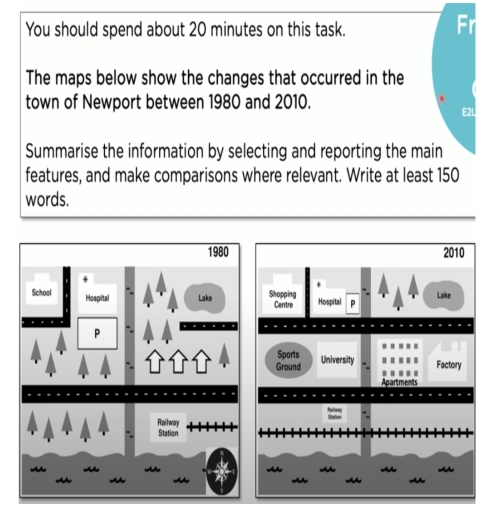
The two maps present the changes that happened in Newport town from 1980 to 2010.
Overall, the town experienced significant development over the 30-years period. Several new facilities such as a sports ground, a university, apartments and factory were constructed, while small natural areas were replaced by urban infrastructure. However,the hospital, a lake and railway lines remained in the same place.
In 1980, the northwest area of the town contained a school and a hospital, with a car park area located just south of the hospital. In the northeast area, there was a large green space with a lake and a number of trees. In the south part of town, there was a railway station near to the railway line, and most of these free areas were covered by trees.
By 2010, Newport town had become more developed. The school was replaced with a shopping center, and a car park area relocated in the southeast part of the hospital, and became smaller. Under these two buildings new roads were constructed. The former housing areas were redeveloped into a sports ground, a university, apartments and factory facilities. In addition, the trees which were located in the southwest side, were replaced with a railway station.
Word Count: 203