Our system will evaluate the answer based on this AI-generated description.
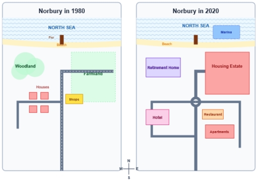
The image shows two comparative site maps titled 'Norbury in 1980' and 'Norbury in 2020', oriented with a central bottom compass rose marked with 'N', 'S', 'E', and 'W'. In the 1980 map, the northern boundary features the 'NORTH SEA' bordered by a 'Beach' strip with a 'Pier' extending into the water; inland features include 'Woodland' in the northwest, a large rectangular 'Farmland' in the northeast, and a road extending from the south that turns east into the Farmland and branches west with a southward turn; along this western branch are four plots labeled 'Houses' (two north, two south), and adjacent to the east of the main road is a block labeled 'Shops'. In the 2020 map, the 'NORTH SEA' contains the 'Pier' and an added rectangular 'Marina' to its east along the 'Beach'; inland, the northwest features a 'Retirement Home', the northeast contains a large 'Housing Estate', and the road network features a central roundabout connecting a south road, a branch leading northeast to the Housing Estate, a branch looping southwest around a 'Hotel', and a branch extending east and turning south, with a 'Restaurant' and 'Apartments' located in the southeast quadrant.
Given the complexity of the image, the above description may not be entirely accurate.
Skyrocket your IELTS band score by 1-2 points in under a month with our premium plan!
Note: Both the topic and the answer were created by one of our users.
The map illustrates the structural development of the coastal village of Norbury over 40-year period from 1980 to 2020. From an overall perspective, it is readily apparent that the village was turned from a rural area to a modernized place. The transition included the expansion in residential, construction on additional roads and opening up more commercial buildings.
In 1980, there was a large farmland in the north-east of the village, while a woodland was located in the north-west of the village. Over 40-year period, they were demolished and transformed to residential. While the woodland was replaced by the retirement home, the large farmland was pulled down and rebuilt to a huge housing estate. Moreover, a marina was constructed nearby the pier.
Infrastructure and commercial buildings were also well developed. In 1980, there were only a few houses and shops next to the roads. After the development, both of them were removed. The extra roads were installed and connected with the original roads. While the hotel was added in south-west of the village and passed through the road, the restaurants and apartments were built in the opposite side across from the main road from north to east.
Word Count: 196
