Our system will evaluate the answer based on this AI-generated description.
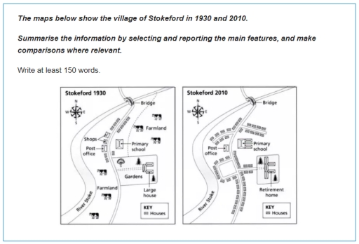
The image displays two maps of the village of Stokeford, comparing its layout and infrastructure in the years 1930 and 2010. In 1930, the village contains several small houses, a post office near the center, a large house surrounded by gardens to the south, and a primary school slightly north-east of the post office. The farmland occupies the eastern section, while shops, indicated by a single icon, lie west of the post office. A single bridge is shown on the road that curves through the northern part of the village. By 2010, the village has undergone significant changes: the number of houses appears increased, the post office remains, but the shops are no longer present. The large house and gardens have been replaced by a retirement home. The primary school remains in a similar location but seems smaller in size. The bridge is still present, and the farmland is no longer depicted, suggesting possible development or a change in land use. The layout of the road system appears more structured with smoother curves compared to 1930. These maps collectively indicate urban development and structural changes in the village over an 80-year period.
Given the complexity of the image, the above description may not be entirely accurate.
Skyrocket your IELTS band score by 1-2 points in under a month with our premium plan!
Note: Both the topic and the answer were created by one of our users.
The illustration represents the different aspects of the village of Stokeford in 1930 and 2010. The aim of this comparison is to describe it’s changement over time.
Generally speaking, the village build didn’t change. The river stoke is still existing after this 80 years, which is rare due to the climate changement nowadays. The principal road follows the same path and both of the post office and the primary school have the same location. But if we look closely at the picture we realize that there’s in fact a significant recomposition.
In 1930, the data reveals Stokeford’s north and south lands were dedicated to the agriculture industry. Farming was the main activity of the village, few houses are located around with shops at there disposition, a post office to ensure security and a primary school to deliver education to the citizens, we also observe the presence of a large house with a huge garden taking place in the middle of the space, contrarly to 2010, where we remark a total absence of this residence.
In contrast, we have in 2010, the apparation of many small houses all along of the main road, and a whole retirement home attached to a neighborhood, allowing to it is resident to receive visits easily, we also notice the disparition of all the farming activity remplaced by spacious streets, and the expansion of the school, due to the big amount of arrivants.
To conclude, the village of stokeford experienced an evolution over time.
Word Count: 248
