Our system will evaluate the answer based on this AI-generated description.
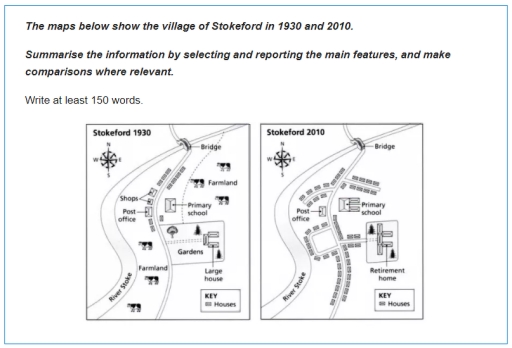
The image displays two maps of the village of Stokeford, comparing its layout and infrastructure in the years 1930 and 2010. In 1930, the village contains several small houses, a post office near the center, a large house surrounded by gardens to the south, and a primary school slightly north-east of the post office. The farmland occupies the eastern section, while shops, indicated by a single icon, lie west of the post office. A single bridge is shown on the road that curves through the northern part of the village. By 2010, the village has undergone significant changes: the number of houses appears increased, the post office remains, but the shops are no longer present. The large house and gardens have been replaced by a retirement home. The primary school remains in a similar location but seems smaller in size. The bridge is still present, and the farmland is no longer depicted, suggesting possible development or a change in land use. The layout of the road system appears more structured with smoother curves compared to 1930. These maps collectively indicate urban development and structural changes in the village over an 80-year period.
Given the complexity of the image, the above description may not be entirely accurate.
Skyrocket your IELTS band score by 1-2 points in under a month with our premium plan!
Note: Both the topic and the answer were created by one of our users.
The maps below offer a comparison of how the village of Stokeford looked in 1930 and 2010.
Overall, significant growth of population and expansion of roads in village is crystal clear to see.
It’s visible that large part of village which has been farmland in 1930 had been cleared out. Instead, the roads, surrounded by residence houses, were constructed in the areas. Covering reasonable part of the village, gardens with large houses were transformed into retirement houses. On the left side of the main road, we can see shops in 1930 which are not detectable in 2010 map. On the other hand, Post office and Primary school have stayed untouched, excluding the fact that two places of residences were built behind the school. Getting closer to the end, we can see two new roads spreading to right and left from the central road in 2010. At the end of the village, the bridge crossing the river has stayed stable over all those years.
Word Count: 163
