Our system will evaluate the answer based on this AI-generated description.
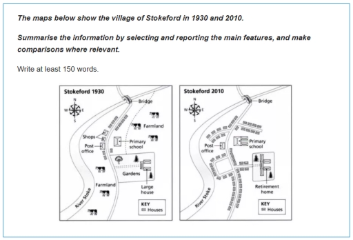
The image displays two maps of the village of Stokeford, comparing its layout and infrastructure in the years 1930 and 2010. In 1930, the village contains several small houses, a post office near the center, a large house surrounded by gardens to the south, and a primary school slightly north-east of the post office. The farmland occupies the eastern section, while shops, indicated by a single icon, lie west of the post office. A single bridge is shown on the road that curves through the northern part of the village. By 2010, the village has undergone significant changes: the number of houses appears increased, the post office remains, but the shops are no longer present. The large house and gardens have been replaced by a retirement home. The primary school remains in a similar location but seems smaller in size. The bridge is still present, and the farmland is no longer depicted, suggesting possible development or a change in land use. The layout of the road system appears more structured with smoother curves compared to 1930. These maps collectively indicate urban development and structural changes in the village over an 80-year period.
Given the complexity of the image, the above description may not be entirely accurate.
Skyrocket your IELTS band score by 1-2 points in under a month with our premium plan!
Note: Both the topic and the answer were created by one of our users.
The maps illustrate the modernization of the village between 1930 and 2010
Overall, a comparison of two maps reveals a transformation from largely rural to urban area. T he farmlands were compeletly removed and new houses were constructed in some of their area.
In detail, new additional branches were added to the long road that crossed through the village. In the west side of the road, two shop stores beside the road were demolished and new houses were built. In the middle of the road, the farmland on the western side was transformed to a new roundabout and was surrounded with small houses.
In the east side of the road, the primary school was upgraded and enlarged. Additionally, the large house was used as a retirement home in 2010 and also was enlarged in order to accomodate more people. The path that connected the retirement house to the main road was upgraded. Furthermore, the new houses were erected along the road.
Word Count: 161
