🔥 Today Only: Save 30% on Premium — Offer Ends Soon! - Upgrade Now!
Map

Band 6+: The maps show how a public building changed over different periods of time.

Image for topic: The maps show how a public building changed over different periods of time.
Our system will evaluate the answer based on this AI-generated description.
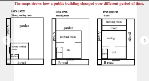
The image features three floor plan diagrams titled "The maps shows how a public building changed over different period of time." The first diagram, titled "198X-19XX" with subtitle "History reading room", is bounded by "A Road" on the left and "B road" at the bottom, containing a large "garden" in the upper-right section and a building section at the lower-left labeled "history reading room" with a smaller internal corner section labeled "kitchen". The second diagram, titled "19xx-19xx" with subtitle "meeting room", is bounded by "A road" on the left and "B road" at the bottom, featuring a reduced "garden" at the top and an enlarged building structure containing a "meeting room", a "hal", and a "kitchen". The third diagram, titled "19xx-present" with subtitle "theatre", is bounded by "A road" on the left, "B road" at the bottom, and a "garage" on the right, fully replacing the garden with building spaces including a "dressing room" at the top, followed vertically by a "... room", a "seating" area, an "office" in the bottom-left corner, and a "hall" at the bottom.
Given the complexity of the image, the above description may not be entirely accurate.
Note: Both the topic and the answer were created by one of our users.

The maps depict the development and transformation of a public building over three distinct periods.

Overall, a public building has witnessed a significant change during three periods. The main change is the use of this are through three periods. In the first period, this public building was used to make history reading room, while in the second one, this transform to make meeting room and in the last one, theatre has constructed in this land

In 198X-19XX, a public building was used as a history reading room. There was a small kitchen in the southwest – hand side of a public building, which was covered by large history reading room. The rest of the was a garden. In the 19XX-19XX period, this building was transformed to meeting room. The kitchen and the garden were remained, while the history reading room was replaced by two floors: the meeting room and the hall.

In 19XX-present period, there has been lots of new places built. The theatre has been constructed instead of the meeting room in the previous period. The Office has been used in the land of kitchen in the 19XX-19XX period. While the hall has been remained, the meeting room has been replaced by the seating. The garage has been built in the east side for parking, as well as … room and dressing room have been constructed in the rest area of the theatre.

Word Count: 234

Answers On The Same Topic:

The maps show how a public building changed over different periods of time.

The three maps illustrate the development of a public building in three periods of time. Overall, the building has undergone dramatic changes, the most important of which is the redesign of functional areas, transforming from the history reading room into the meeting room and then converting into the theatre in the present. In the first […]

The maps show how a public building changed over different periods of time.

The map provides information of a public building’s reconstruction over a span of three centuries. Overall, the building changed its designation every time a reconstruction was made. The number of rooms expanded over the centuries. From 18xx to 19xx centuries the public building intended to be a history reading room. The building had around five […]

The maps show how a public building changed over different periods of time.

The maps depict the changes of a public building and the surroundings across three distinct periods. Overall, the building underwent significant expansions and functional changes, successively serving as a history reading room, a meeting room and a theater. Concurrently, it is also noticeable that the garden was progressively reduced before being completely replaced by other […]

The maps show how a public building changed over different periods of time.

The maps illustrate the changes of a public building over different periods of time. Overall, the building underwent a number of dramatic changes, the most important of which are the redesign of functional areas, with the history reading room being converted into the meeting room and then replaced by the theatre in the present. In […]

See All

Other Topics:

The maps below show the changes that have taken place at Westfield Airport between 1980 and the present day.

The maps illustrate the changes that have taken place at Westfield Airport between 1980 and the present day. Overall, the airport has become more modren and expeanded. In 1980, Westfield Airport had just one terminal and shops and restaurants in the center. Below them, there was a covered walkway, and a car park below it. […]

The map given below shows the plan for reconstruction of the second floor of Mason's Building. Summarise the information by selecting and reporting the main features, and make comparisons where relevant.

The maps compare the current layout of the secord floor of Mason’s building and its proposed redevelopment plan. Overall, the floor will be exstensily redesigned from a residential area into a studio. The bathroom and landing will remain unchanges, while all the reamain rooms will be transformed. The kitchen and bedroom 3 will be converted […]

The diagrams below show the plan of a small school in 1980 and in 2010.

The map illustrates the reconstruction of a university department in 1980 and 2010. Overall, it can be seen that the main changes in the size of a university, also some changes in the outside. The university was expanded, instead of three seminar rooms, in 2010 there is five seminar rooms. So, the coridor turned longer […]

The two maps below show an island, before and after the construction of some tourist facilities. Summarise the information by selecting and reporting the main features, and make comparisons where relevant.

The maps illustrate the developments that took place on the island. Overall, the major changes took place in the central and western parts of the island, while the eastern side remained unchanged, with the appearance of various tourism facilities. Regarding the map of the original island, the landscape had a length recorded at around 230 […]

The maps give information about the village of Stokeford in 1930 and 2010. Summarize the information by selecting and reporting the main features and make comparisons where relevant.

The two maps illustrate how the village of Stokeford changed over an 80-year period from 1930 to 2010. Overall, the village underwent significant redevelopment, with many original features being removed or replaced. More residential and recreational facilities were added, including retirement homes and new housing, while the post office and the bridge remained unchanged. In […]

The maps below show the village of Stokeford in 1930 and in 2010. Summarize the information by selecting and reporting the main features, and make comparisons where relevant.

The given two maps illustrate how the village of Stokeford changed over an 80 years period from 1930 to 2010. Overall, the village has undergone significant redevelopment, with many original places being removed or replaced. Recreational and more residential facilities have been added, including retirement homes, houses, while the Post office and bridge remain unchanged. […]

See All
We have detected unusual activity on your device.
Please verify your identity to continue.
Note: This verification step won't sign you in. If you have a premium account, please log in to access the service as usual.
Google/Gmail Verification
Or verify using Email/Code
We've sent a verification code to:
youremail@gmail.com (Not your email?)
Enter it below to complete the verification process.
Ensure your email address is correct, your inbox is not full, and you check your spam folder. If no email arrives, consider using an alternative email.
You will need a Premium plan to perform your action!
Note: If you already have a premium account, please log in to access our services as usual.

Plans & Pricing

Our mission is to make quality education accessible for everyone.
However, to keep our hardworking team running and this service alive, we genuinely need your support!
By opting for a premium plan, not only do you sustain us in achieving the mission, but you also unlock advanced features to enrich your learning experience.

Free

For learners who aren't pressed for time

What's included on Free
100+ Cambridge IELTS Tests
Instant IELTS Writing Task 1 & 2 Evaluation (2 times/month)
Instant IELTS Speaking Part 1, 2, & 3 Evaluation (2 times/month)
Instant IELTS Writing Task 1 & 2 Essay Generator (2 times/month)
500+ Dictation & Shadowing Exercises
100+ Pronunciation Exercises
Flashcards
Other Advanced Tools

Premium

For those serious about advancing their English proficiency, and for IELTS candidates aspiring to boost their band score by 1-2 points (especially in writing & speaking) in just 30 days or less

What's included on Premium
Save Your IELTS Test Progress & Analyze Mistakes By Question Type
Save Your Own Flashcard Sets & Use Them On Any Device
Unlock All Courses, IELTS Tests, Section & Part Practice
Unlimited AI Conversations
Unlimited AI Writing Enhancement Exercises
Unlimited IELTS Writing Task 1 & 2 Evaluation
Unlimited IELTS Speaking Part 1, 2, & 3 Evaluation
Checked Answers Will Not Be Published
Unlimited IELTS Writing Task 1 & 2 Essay Generator
Unlimited IELTS Speaking Part 1, 2, & 3 Sample Generator
Unlimited Usage Of Advanced Tools & AI Features
Priority Support within 24h (12-month plan only)

Due to the nature of our service and the provided free trials, payments are non-refundable.