Our system will evaluate the answer based on this AI-generated description.
The image contains two diagrams depicting the transformation of a coastal land area before and after its development into a coastal park. The top diagram, labeled "before development," shows a delineation featuring segments of agricultural land, a section for farm buildings neighbored by an area for animals, and an unused land portion. This part is bounded by cliffs to the side of the sea, with details of a beach below the cliffs. There are footpath markings running horizontally across the upper portion. The bottom diagram, labeled "after development," illustrates modifications including the addition of a road entering from the upper-left corner, culminating at a car park adjacent to a café. There is a lake situated centrally, surrounded by areas marked as woods with tree symbols. The layout maintains the cliffs and beach adjacent to the sea, preserving their earlier positions. Footpaths now appear to traverse more dynamically throughout the park, featuring steps indicated along the paths by the cliffs.
Given the complexity of the image, the above description may not be entirely accurate.
Skyrocket your IELTS band score by 1-2 points in under a month with our premium plan!
Note: Both the topic and the answer were created by one of our users.
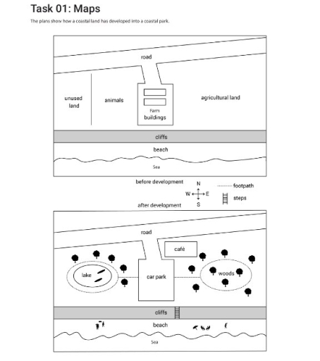
The maps illustrate how a coastal land has modernized into a coastal park.
Overall, there were some significant changes in the middle of the layout, while the other sides do not look different from the original.
Look at the centre of the map, before development, there were some farm buildings which connected to the road through a large path. However, after the development, it was demolished to make room for a car park and a cafe next to it. To the left of it was an area which was separated into two purposes: animals and unused land. On the opposite, the whole land was used for agricultural purposes. After the modernization, there is a new lake on the western side and a forest on the northern one. A noticeable point is that there are a lot of trees surrounding them and residents can walk from car park to these places on footpaths.
As new steps is built to connect the middle of the map to the southern, citizens can go to the beach and enjoy activities there.
Word Count: 177