🔥 Today Only: Save 30% on Premium — Offer Ends Soon! - Upgrade Now!
Map

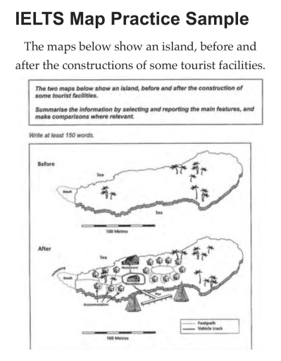
Band 9: The two maps below show an island, before and after the construction of some tourist facilities Summarise the information by selecting and reporting the main features, and make comparisons where refevant.

Image for topic: The two maps below show an island, before and after the construction of some tourist facilities Summarise the information by selecting and reporting the main features, and make comparisons where refevant.
Our system will evaluate the answer based on this AI-generated description.
The image presents two maps comparing an island before and after the addition of tourist facilities. The "Before" map displays a simple, undeveloped island featuring sparse vegetation, predominantly palm trees scattered along the island's surface and coastline with no visible infrastructure. In contrast, the "After" map introduces significant developments: a footpath running around a housing area, a vehicle track leading to a reception building, which is centrally located, and a restaurant positioned slightly north near the sea. Accommodation units are clustered around the reception, comprising two blocks on either side. The island's perimeter features a pier toward the western shore with boat access; the beach area located to the west is adjusted for swimming activities. The remaining areas continue to maintain palm trees, preserving some of the island's natural elements. The scale is consistent in both maps, depicting a measured distance of 100 meters for clarity in size reference.
Given the complexity of the image, the above description may not be entirely accurate.
Note: Both the topic and the answer were created by one of our users.

The two maps illustrate how an island has changed following the development of tourist facilities.

To begin with, the island was originally undeveloped, containing only natural features such as trees and a beach on the western side. There were no buildings, roads, or other infrastructure.

However, after the construction, the island was significantly transformed to accommodate tourists. First of all, two separate areas of accommodation huts were built—one near the beach in the west and another in the centre of the island. These huts are connected by footpaths. In between them, a reception building was constructed, with a restaurant located to the north of it.

In addition, a pier was built on the southern coast, allowing access for boats. A vehicle track connects the pier with both the reception and the restaurant. Moreover, the beach area is now used for swimming.

In conclusion, the island changed from a natural space to a tourist destination, with careful planning to include both facilities and access while keeping some green areas.

Word Count: 168

Answers On The Same Topic:

The two maps below show an island, before and after the construction of some tourist facilities Summarise the information by selecting and reporting the main features, and make comparisons where refevant.

The two maps below illustrate the original appearance of the island and reconstruction from tourism’s students. Overall, the upper map shows an uninhabited island with minimal infrastructure and no building.The final version of the island has highly developed infrastructure ,including a hotel for leisure. Initially,the island was washed by two seas.There were only a few […]

The two maps below show an island, before and after the construction of some tourist facilities Summarise the information by selecting and reporting the main features, and make comparisons where refevant.

The given maps illustrated an island, before and after the construction of some tourist facilities. Overall, the island is surrounded by the sea, it has a beach and some trees originally, after the modernisation. Some tourist facilities are added, such as harbour and accommodations. According to the maps, after the renovation. A pier is added. […]

See All

Other Topics:

The maps below show the changes in area after construction of a hydroelectric power dam. Summarise the information by selecting and reporrting the main features, and make comparisons where relevant.

The maps illustrate a comparison of the area before and after the construction of a hydroelectric dam in 1980 and 2000. In 1980, there was a main river surrounded by large mountains, forests, and villages. The forest was rich in rare plants and animals, and people at that time made a living through agriculture. They […]

The map below is of the town od galdson. A new supermarket is planned for the town. The map shows two possible sites for the supermarket.

THE MAP BELOW ILLUSTRATES THE TOWN, CALLED GARLSDON, AND IT IS PLANNED TO BUILD A NOVEL SUPERMARKET IN ONE OF THE TWO POSSIBLE SITES. OVERALL, THE TOWN OF GARLSDON CONSISTS OF 65000 INDIVIDUALS. BOTH THE NORTH AND SOUTH SIDE OF THE TOWN IS USED FOR INDUSTRY, WHILE THE MOST PART OF IT BELONGS TO HOUSING. […]

The maps below show the changes that have taken place at the waterfont area of a town called Darwin between 2009 and 2014.

The maps above illustrate how place at the waterfont area of a town named Darwin has changed between 2009 and 2014. Looking from an overall perspective, the number of swimming pools has decreased, and several new facilities have been built. Furthermore, it is seen that industrial area has transformed into a territory with many trees […]

The maps show the changes of an office building between the present and the future. Summarize the information by selecting and reporting the main features, and make comparisons where relevant.

The presented maps illustrates the transformation of an office building between nowadays and the future. Overall, it is obvious that the office building is predicted to witness significant transformations, with the most noticeable being the addition of several facilities including the offices, the canteen, the storeroom, the wcs, etc and the disappearance of the kitchen […]

The Maps show construction between 2007 and 2012 in Stratford in preparation for the 2012 London Olympic Games.

The maps show changes from 2007 and 2012 in Stratford to be prepared for London Olympic games in 2012. Overall, the city underwent remarkable developments over the time period. The most significant change is that the city became more facilitated for the 2012 London Olympic games by constructing Olympic facilities in both north and south […]

The two maps bello show road access to a city hospital in 2007 and 2010. Summarize the information by selecting and reporting the main features and make comparisons wherever revelant.

The two diagrams represent the road access between a city hospital in 2007 and 2010. Overall, the road layout underwent several significant changes over three years. While the ring road and City Road remained the same, a new bus station replaced the previous bus stop, a roundabout was removed, and the parking facilities were reorganized. […]

See All
We have detected unusual activity on your device.
Please verify your identity to continue.
Note: This verification step won't sign you in. If you have a premium account, please log in to access the service as usual.
Google/Gmail Verification
Or verify using Email/Code
We've sent a verification code to:
youremail@gmail.com (Not your email?)
Enter it below to complete the verification process.
Ensure your email address is correct, your inbox is not full, and you check your spam folder. If no email arrives, consider using an alternative email.
You will need a Premium plan to perform your action!
Note: If you already have a premium account, please log in to access our services as usual.

Plans & Pricing

Our mission is to make quality education accessible for everyone.
However, to keep our hardworking team running and this service alive, we genuinely need your support!
By opting for a premium plan, not only do you sustain us in achieving the mission, but you also unlock advanced features to enrich your learning experience.

Free

For learners who aren't pressed for time

What's included on Free
100+ Cambridge IELTS Tests
Instant IELTS Writing Task 1 & 2 Evaluation (2 times/month)
Instant IELTS Speaking Part 1, 2, & 3 Evaluation (5 times/month)
Instant IELTS Writing Task 1 & 2 Essay Generator (2 times/month)
500+ Dictation & Shadowing Exercises
100+ Pronunciation Exercises
Flashcards
Other Advanced Tools

Premium

For those serious about advancing their English proficiency, and for IELTS candidates aspiring to boost their band score by 1-2 points (especially in writing & speaking) in just 30 days or less

What's included on Premium
Save Your IELTS Test Progress
Unlock All Courses & IELTS Tests
Unlimited AI Conversations
Unlimited AI Writing Enhancement Exercises
Unlimited IELTS Writing Task 1 & 2 Evaluation
Unlimited IELTS Speaking Part 1, 2, & 3 Evaluation
Checked Answers Will Not Be Published
Unlimited IELTS Writing Task 1 & 2 Essay Generator
Unlimited IELTS Speaking Part 1, 2, & 3 Sample Generator
Unlimited Usage Of Advanced Tools
Priority Support within 24h (12-month plan only)

Due to the nature of our service and the provided free trials, payments are non-refundable.
Nếu bạn là người Việt Nam và không có hoặc không muốn trả bằng credit/debit cards, bạn có thể thanh toán bằng phương thức chuyển khoản:


Chọn gói:
419,000₫ 277,000 ₫ cho gói 1 tháng (chỉ 9,233₫/ngày)
1,239,000₫ 597,000 ₫ cho gói 3 tháng (chỉ 6,633₫/ngày)
2,469,000₫ 1,027,000 ₫ cho gói 6 tháng (chỉ 5,706₫/ngày)
4,929,000₫ 1,417,000 ₫ cho gói 12 tháng (chỉ 3,936₫/ngày)


Sau khi chuyển khoản, vui lòng đợi trình duyệt tự động điều hướng bạn trở lại Engnovate và bạn sẽ ngay lập tức nhận được mã kích hoạt tài khoản premium.
Nếu có lỗi xảy ra, bạn có thể liên hệ với team thông qua một trong các phương thức: email đến helloengnovate@gmail.com hoặc nhắn tin qua facebook.com/engnovate.
Vì toàn bộ công cụ trên website đều có thể sử dụng thử miễn phí, Engnovate không hỗ trợ hoàn tiền.