🔥 Today Only: Save 30% on Premium — Offer Ends Soon! - Upgrade Now!
Map

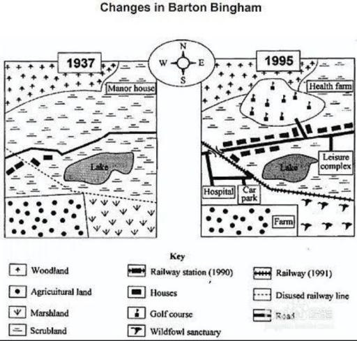
Band 8+: The two maps below which show the area of barton Bingham in 1937 and 1995

Image for topic: The two maps below which show the area of barton Bingham in 1937 and 1995
Our system will evaluate the answer based on this AI-generated description.
The image shows two maps comparing Barton Bingham in 1937 and 1995. In 1937, elements included a manor house in woodland in the northwest, a railway running west to east through the northern area, agricultural land north and west of the railway, a lake surrounded by marshland in the center, scrubland southeast, and a road running south from the railway station through the scrubland. By 1995, the manor house had become a health farm, the railway had additional lines and disused segments, agricultural areas converted into leisure complex and healthcare facilities including a hospital and car park west of the lake, woodland largely replaced by places like a golf course and minor commercialization, marshland near the lake was removed or diminished, and scrubland converted to a farm. Wildfowl sanctuary introduced in scrubland area, roads and infrastructure expanded connecting new urban elements.
Given the complexity of the image, the above description may not be entirely accurate.
Note: Both the topic and the answer were created by one of our users.

The diagram illustrates the significant development changes that took place in specific areas between 1937 and 1995.

Overall, it is clear that the area has been extensively modernized over nearly six decades. In agricultural land and scrubland spaces are entirely replaced by a leisure complex, a hospital and a car park.

In 1937, the northern section of the area was classified as a manor house surrounded by woodland, along with a vast expanse of scrubland. By 1995, the area had undergone significant redevelopment. The original manor house was converted into a health farm, while the vast scrubland was entirely cleared to make room for a large golf course.

Turning to the central and southern areas of the map, the agricultural land in the southwest was reduced in size to make space for a farm, while the marshland in the southeast was handed over by a wildfowl sanctuary. A new road and a railway line complete with a station were constructed directly across the area. A hospital and a car park were built alongside with new transport links, a leisure complex was developed next to the lake, and several houses were erected along the new main road.

Word Count: 196

Answers On The Same Topic:

The two maps below which show the area of barton Bingham in 1937 and 1995

The diagrams illustrate the significant development changes that took place in Barton Bingham between 1937 and 1995. Overall, it is clear that the area had been extensively modernized over nearly six decades. In agricultural land and scrubland spaces are entirely replaced by a leisure complex, a hospital and a car park. Specifically, In 1937, the […]

The two maps below which show the area of barton Bingham in 1937 and 1995

The pictorial representations demonstrate developments in the particular region of Barton Bingham in 1937 and 1995. Overall, it can be noticed that the leisure facilities have been develop in this zone.Add to this, the eminities was created like, hospital, railway station.Moreover, the lake was same as in the previous year. By analysing the data, the […]

The two maps below which show the area of barton Bingham in 1937 and 1995

The two maps illustrate how the village of Barton Bingham changed between 1937 and 1995. Overall, Barton Bingham was transformed from a largely rural area into a more developed settlement with improved transport infrastructure, additional housing, and several healthcare and recreational facilities. Nevertheless, the lake and some areas of woodland, scrubland and agricultural land were […]

The two maps below which show the area of barton Bingham in 1937 and 1995

The two maps illustrates the changes in the development of the area Barton Bingham in 1937 and 1995. Overall, although the most of the field area was covered by different lands in 1937, this lands were reduced due to construction of new buildings and constitutions in 1995. In 1937, most of the area of Barton […]

See All

Other Topics:

The maps beiow show the changes experienced by the tovvn of Harton at the beginning of the 21 st Century. Summarise the information by se/ecting and reporting the main features and make comparisons where necessary.

the map displays the main change which took place in the town of Harton between 2008 and 2016. Overall, it is immidiately noticable that Harton has become a much modern city, with far more buildings and facilities. Meanwhile, the natural area followed the opposite pattern, getting smaller space. to begin with the northwest part, the […]

summarise the changes in the layout of the Woodwards University.

The diagram illustrates the transformation of the university campus from 1985 to present day. In 1985, the university had several academic buildings. The library was situated in the north west, while the Physics, Chemistry and Biology Block were separate structures located in the north east. On campus there were two car parks, one was on […]

TASK 1 - The maps give information about a university sports court.

The given maps demonstrate how university sports courts have been changed over time, in 1990 and the present days. Overall, the park and its car park were removed from the courts which filled the whole left part of the university courts. The area has become more focused on recreational facilities , where there are no […]

The maps below show an industrial area in the town of Noribton, and planned future developments of the site.

The two maps illustrate what the industrial area in town of Norbiton looks like today, and developments for future. Overall, all an area town of Norbiton central is projected to a significant transformation with modern objects. The centre town of fully extended with modern objects. At present, in terms of the central part of the […]

The maps below show an industrial area in the town of Noribton, and planned future developments of the site.

The two maps illustrate how developing part of Noribton looks prior to development and how it will be incorporated. overall, the area will be transformed from industrial complex to residential zoning. Furthermore, there will be built the bridge across the river. Currently, there are roundabout located in the south of the river, which connect the […]

The maps below describe a town in the Atlantic Ocean affected by a volcanic eruption in 1706. Summarise the information by selecting and reporting the main features and make comparison where relevant.

The maps illustrate how a town in the Atlantic Ocean was affected by a volcanic eruption in May 1706, while a separate diagram indicates the location of the volcano relative to the settlement. Overall, the eruption caused substantial changes to the town. Whereas the residential area and town square survived, the castle and port were […]

See All
We have detected unusual activity on your device.
Please verify your identity to continue.
Note: This verification step won't sign you in. If you have a premium account, please log in to access the service as usual.
Google/Gmail Verification
Or verify using Email/Code
We've sent a verification code to:
youremail@gmail.com (Not your email?)
Enter it below to complete the verification process.
Ensure your email address is correct, your inbox is not full, and you check your spam folder. If no email arrives, consider using an alternative email.
You will need a Premium plan to perform your action!
Note: If you already have a premium account, please log in to access our services as usual.

Plans & Pricing

Our mission is to make quality education accessible for everyone.
However, to keep our hardworking team running and this service alive, we genuinely need your support!
By opting for a premium plan, not only do you sustain us in achieving the mission, but you also unlock advanced features to enrich your learning experience.

Free

For learners who aren't pressed for time

What's included on Free
100+ Cambridge IELTS Tests
Instant IELTS Writing Task 1 & 2 Evaluation (2 times/month)
Instant IELTS Speaking Part 1, 2, & 3 Evaluation (2 times/month)
Instant IELTS Writing Task 1 & 2 Essay Generator (2 times/month)
500+ Dictation & Shadowing Exercises
100+ Pronunciation Exercises
Flashcards
Other Advanced Tools

Premium

For those serious about advancing their English proficiency, and for IELTS candidates aspiring to boost their band score by 1-2 points (especially in writing & speaking) in just 30 days or less

What's included on Premium
Save Your IELTS Test Progress & Analyze Mistakes By Question Type
Save Your Own Flashcard Sets & Use Them On Any Device
Unlock All Courses, IELTS Tests, Section & Part Practice
Unlimited AI Conversations
Unlimited AI Writing Enhancement Exercises
Unlimited IELTS Writing Task 1 & 2 Evaluation
Unlimited IELTS Speaking Part 1, 2, & 3 Evaluation
Checked Answers Will Not Be Published
Unlimited IELTS Writing Task 1 & 2 Essay Generator
Unlimited IELTS Speaking Part 1, 2, & 3 Sample Generator
Unlimited Usage Of Advanced Tools & AI Features
Priority Support within 24h (12-month plan only)

Due to the nature of our service and the provided free trials, payments are non-refundable.