Our system will evaluate the answer based on this AI-generated description.
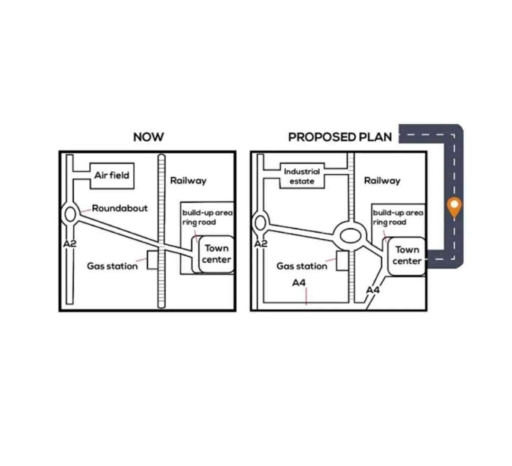
The image contains two diagrams, labelled "NOW" and "PROPOSED PLAN," depicting two different layouts of an area with various features. In the "NOW" diagram, there is an Airfield in the top left corner connected to a Roundabout, which is linked to three roads - one towards the Gas station in the bottom left corner, one towards the Town center in the middle right, and one intersecting a Railway with a Bridge above the Railway, leading upwards with 'build-up area' written alongside. A fourth road encircles the Town center marked as 'ring-road'. In the "PROPOSED PLAN" diagram, the layout is slightly altered; the 'Industrial estate' now appears above the Railway in the upper right corner, connected to a modified 'ring-road' with 'build-up area' written along it again. The Gas station has moved towards the bottom right and is positioned on a new road labelled 'A4' extending outside of the diagram's boundary, marked with a dashed line. The Roundabout, Airfield, and Town center remain in similar positions, and 'A2' is written alongside the road between the Roundabout and Industrial estate.
Given the complexity of the image, the above description may not be entirely accurate.
Skyrocket your IELTS band score by 1-2 points in under a month with our premium plan!
Note: Both the topic and the answer were created by one of our users.
The given maps illustrate the present day layout of a town and a development plan for the future. Overall, significant changes in infrastructure are planned, including new residential area, commercial, and redeveloped facilities, along with improved road connectivity.
At present, the town consists of main road from north to south, along by a smaller road in the center. There are a few residential houses with the roads, and open green spaces are visible on other side. The northern and southern ends of the town appear to be undeveloped with large open areas.
In the proposed development plan, the town will be developed with a major transformations. The central road will be widened to include a roundabout, improving traffic. Additional roads will be constructed, providing better access to new residential areas. The current open green spaces will be replaced with various facilities, such as shopping centers, recreational parks, and parking lots. A new commercial zone is planned in the eastern part of the town, while more houses will be added, significantly increasing the residential area.
In conclusion, the town is all set to witness effective modernization, with improved infrastructure, increased housing, and enhanced commercial and recreational facilities, making it more urbanized and accessible.
Word Count: 202