Our system will evaluate the answer based on this AI-generated description.
The image depicts two triangular diagrams representing tropical and temperate mountain altitudes, divided into various ecological zones. Tropical mountain altitude ranges from 0 to 5,500 meters (18,000 feet). Warm zone is 0-1,000 meters (0-3,300 feet) for tropical crops. Temperate zone is 1,000-2,000 meters (3,300-6,600 feet) for coffee and cocos. Cool zone is 2,000-3,000 meters (6,600-10,000 feet) for grain cultivation. Forest begins at 3,000 meters (10,000 feet), with a limit for broad-leaf trees at 3,500 meters (11,500 feet) and pine and firs limit at 4,000 meters (13,000 feet). Alpine meadows start at 4,000 meters (13,000 feet), snow line is at 5,000 meters (16,500 feet), and permanent snow begins at 5,500 meters (18,000 feet). Temperate mountain altitude ranges from 0 to 3,500 meters (12,000 feet). Warm zone is 0-500 meters (0-1,500 feet), Temperate zone is 500-1,000 meters (1,500-3,000 feet), Cool zone is 1,000-1,500 meters (3,000-5,000 feet) for grains, potatoes, flax. Forest begins at 1,500 meters (5,000 feet), with a limit for broad-leaf trees at 2,000 meters (6,500 feet) and spruce limit at 2,500 meters (8,500 feet). Alpine meadows start at 2,500 meters (8,500 feet), snow line is at 3,000 meters (10,000 feet), and permanent snow begins at 3,500 meters (12,000 feet).
Given the complexity of the image, the above description may not be entirely accurate.
Skyrocket your IELTS band score by 1-2 points in under a month with our premium plan!
Note: Both the topic and the answer were created by one of our users.
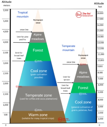
The diagram compares temperature zones of tropical mountains and temperate mountains in their height and floor.
Overall, tropical mountains are significant higher than temperate mountains. Morepver, tropical mountains have a wider range of temperature zones while temperate mountains mainly comprise of cool zone and alpine meadows .
In temperate mountains, they are divided into four distict region. The cool zone, which is bellow 5000 feet (1500 meters) in altitude, is mainly use for cultivation of grains, potatoes and flax. The forest region lied between the limit for broad-leaf trees and spuce trees, which ranging from 5000 to 6000 feet. Alpine meadows are present at around 1000 meters (3000 feet), with figures varying from 2000 to 300 meters. The highest area is permanent snow, nearly peaking at 36000 meters (12000 feet) in altitude.
In tropical mountains, they are extremely tall, measuring approximately 5500 meters (18000 feet) in height and can be divided into 6 areas. Warm zone lied at the bottom, with 500 meters in altitude, which suitable for many tropical crops. Temperate zone is often use to growing crops such as coffee cocoa, located in higher altitude. Grains are grow in cool zone, which lied at a height of approximately 2000 to 3000 meters above sea level. Above this zone is the forest region, where broad-leaf trees can survive until an altitude of 3000 meters, whereas pine and firs trees thrive up to just under 4000 meters. The alpine meadows and snow zone are situated at the top of mounatains, with the snow line at around 4500 meters.
Word Count: 258