Our system will evaluate the answer based on this AI-generated description.
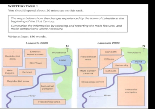
The image consists of two maps labeled Lakeside 2000 and Lakeside 2009, depicting changes in the town's infrastructure. In 2000, from north to south, there is a woodland, lake, old town, residential area, and river, with an arts center to the west, school to the east, industrial complex and two more residential areas to the south, and derelict warehouses to the southwest. By 2009, the northern woodland remains, but the lake is replaced by a pond, the old town becomes offices, the residential area transforms into a car park, and the school expands, with the addition of a university. The arts center becomes a multi-screen cinema, and a shopping center appears north of the southern river. The industrial complex and the southernmost residential area persist, while the central southern residential area and derelict warehouses vanish.
Given the complexity of the image, the above description may not be entirely accurate.
Skyrocket your IELTS band score by 1-2 points in under a month with our premium plan!
Note: Both the topic and the answer were created by one of our users.
The two maps above illustrate how the town of Harton changed in the beginning of the 21st century.Overall, the town experienced slight changes with most accommodation remain the same also with only a building that extended .
The woodland from the north to south of the area was cleared to expand the industrial complex . In addition , a lake that was located on the wood site became a pond .Southwest of area a shopping centre was built on the place where residential area used to be located.Residential area and school to the northwest of the town remained the same over the period.
Arts centre was replaced by multi-screen cinema in the west the Harton town The Derelict warehouse was converted to the car park north of the town while south of derelict warehouses , the old town was knocked down for construction of offices and a university.
Word Count: 148
