Our system will evaluate the answer based on this AI-generated description.
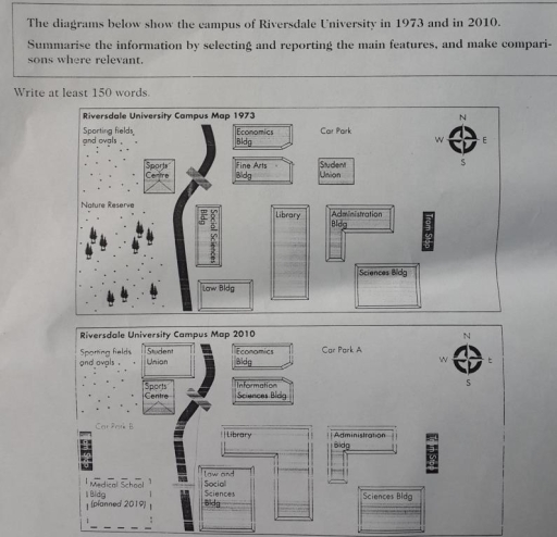
The image presents two campus maps of Riversdale University from 1973 and 2010 respectively; the 1973 map features a Sports Centre, Fine Arts Building, Student Union, Library, Administration Building, Sciences Building, and Law Building, arranged clockwise from the northwest to the southeast, with sports fields to the southwest and a Nature Reserve to the south; Car Park is located northeast, with the compass indicating north to the top right corner; the 2010 map displays an Information Sciences Building on the site of the previous Fine Arts Building, the Sports Centre replaced by Student Union and sports venues moved to the southwest corner, Car Park A replacing the previous Car Park, Car Park B to the southwest, and a new Medical School (planned 2011) in the southeast, with Economics and Social Sciences Building added to the existing layout; the Library, Administration Building, and Sciences Building remain in their original locations; the compass has north pointing to the top right corner.
Given the complexity of the image, the above description may not be entirely accurate.
Skyrocket your IELTS band score by 1-2 points in under a month with our premium plan!
Note: Both the topic and the answer were created by one of our users.
The maps show the developments which Riversdale University Campus experienced during the years 1973 and 2010.
Overall, a comparison of two maps reveals a dramatic change and a noticeable expansions over the 38 years period.
It is clear that, in the south-west corner of the site a significant change observed, in 1973, the corner used to be greener with nature reserves, however these were cleared to make way for the medical School Blog and Car Park B that located just adjacent to a new Tram stop. Further development took place around the sporting fields and by 2010 the student union had been sprang up along the road , which initially used to show up in the north-east . In addition, only one bridge was surveyed in the north-west site in 1973 , but during the next 38 years an another bridge was joint running directly south.
The expansion of educational facilities continued as the Fine Arts Blog turned into the Information Sciences Blog in 2010. Notably, the south zone of the area underwent a slight change, by 2010, the school sciences blog and low blog had been reverted to one building across the bridge. Significantly, there was only one car park in 1973, then that was divided into A,B sections by the end of given period. Finally, the south-eastern corner remained the same as any improvements were not implemented .
Word Count: 230