Our system will evaluate the answer based on this AI-generated description.
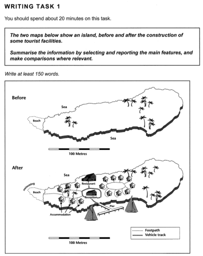
The image contains two maps of an island, one showing the island before the construction of tourist facilities and the other after. The maps are labeled "Before" and "After," respectively, and both have a scale indicating 100 meters. In the "Before" map, the island has a beach on its southwest side and is dotted with palm trees throughout. The "After" map shows significant development, including accommodations in the form of huts arranged in two rows on the northeast side of the island, a reception building, and a restaurant near the center. A vehicle track is depicted connecting the huts, reception, and restaurant, and encircling these facilities is a footpath that also leads to the beach. The beach appears unchanged. There are no numerical data points, percentages, trends, or any other quantifiable indicators provided in the image.
Given the complexity of the image, the above description may not be entirely accurate.
Skyrocket your IELTS band score by 1-2 points in under a month with our premium plan!
Note: Both the topic and the answer were created by one of our users.
The given two maps illustrate the outline of an island, before and after some tourist facilities are constructed.
Overall, while the island’s size remains the same in both maps, the second map has more details in terms of places for foreigners than the first one.
Focusing on the map before it is being renovated, there were a number of trees on the island and the beach on the left side. It contained more free areas on the island and the sea.
Turning to the map after its development, While trees and beach are being unchanged, plenty of accommodation and footpaths are built. Reception can be found in the center, surrounded by a vehicle track, and just above that is a restaurant while below that is a pier for tourists’ boats. On the west side of the island where the beach is located, nearby is a swimming pool at the far end.
Word Count: 151