Our system will evaluate the answer based on this AI-generated description.
The image displays two schematic maps of an industrial area in the town of Norbiton, illustrating the current layout and a planned future development. The first map, labelled "Norbiton industrial area now," features a rectangular factory at the centre, connected to a railway with a platform to the west and bordered by Farmland to the north. Directly east of the factory, there's a road running north-south with three rectangular depots along it. The second map, titled "Planned future development," shows the factory and the existing road with depots. Additions in the future plan include a roundabout south of the factory, an extended platform along the railway, and more structured parking adjacent to the platform. The road extends south in the future plan, connecting to another road that runs east-west, with another roundabout on this junction. Farmland still borders the area to the north but is also planned to the northeast and east of the facility, suggesting potential expansion or preservation of green spaces.
Given the complexity of the image, the above description may not be entirely accurate.
Skyrocket your IELTS band score by 1-2 points in under a month with our premium plan!
Note: Both the topic and the answer were created by one of our users.
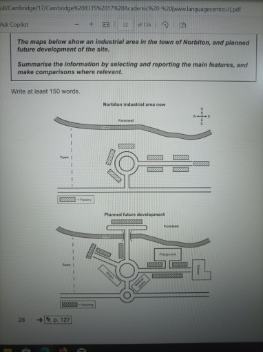
The first map bellow illustrates a site in Norbiton town which is considered as an industrial area, while the second one displays how this area is going to be advanced. Overall, there will be a total changeover there, with shifting it into a residential area instead, and being equipped with recreational, educational, and medical facilities.
In the first map it can be seen that there was a square with two roads at the eastern and southern sides of that, along which the factories were located, whereas, two additional roads are planned to paved in addition to another square. Moreover, another road will be constructed in the farmland, which is accessible via a bridge on the river that is alongside the road
With regards to the facilities, the factories will be demolished and replaced by Houses, while a medical center and shops will be built adjacent to the junction at the bottom of the map. Also, a new playground will be constructed parallel with the eastern initial road, and a school at the end of that, which are greatly reachable to the residents in that site.
Word Count: 185