Our system will evaluate the answer based on this AI-generated description.
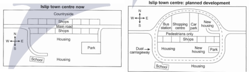
The image contains two side-by-side maps labeled "Islip town centre now" and "Islip town centre: planned development," each with a compass rose indicating north, south, east, and west. The left map shows a countryside to the north, a main road running horizontally with shops on either side, housing to the south of the shops on the west, a school to the southwest, housing to the south of the school, and a park to the southeast of the housing. The right map depicts a dual carriageway on the north, a bus station to the northwest, a shopping centre shaped like an oval with an inner loop labeled "Pedestrians only" surrounded by shops, a car park to the northeast, new housing in dotted lines to the southeast, housing to the south, a school to the southwest, and a park to the east of the school. There are no numerical data points, percentages, or trends visible in the image.
Given the complexity of the image, the above description may not be entirely accurate.
Skyrocket your IELTS band score by 1-2 points in under a month with our premium plan!
Note: Both the topic and the answer were created by one of our users.
The map above shows the centre of a small town called Islip as it is now and its proposed development.
Overall, the Islip town plans to undertake a major development for the town’s benefit.
According to the picture, the Islip town plans to build dual carriageways and pedestrian walkways to avoid endangering or inconveniencing pedestrians and those driving vehicles. Because we can see from the map of Islip town centre now, that the city only has a main road.
Also, the Islip town only has a few public facilities such as shopping places, schools, housing, and parks. So, they are planning to make more public facilities to improve the quality of life of citizens and support economic growth.
Word Count: 118