Our system will evaluate the answer based on this AI-generated description.
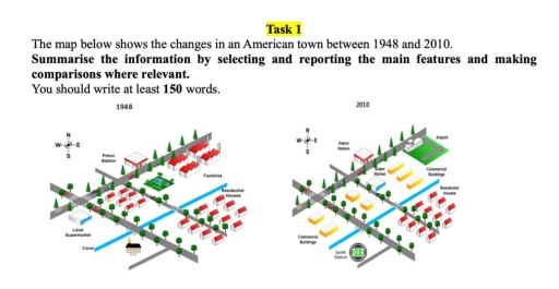
The image displays comparing maps from 1948 and 2010 in an American town, indicating infrastructural evolution: 1948 presents features such as a main road running east-west with a bridge over a river, surrounded by residential houses, factories, and farmland; discernibly, residential buildings are located south of the main road and northwest with factory zones nearby, a canal stretches north-south aligning the eastern section; petrol stations and local supermarkets dot the area with commercial buildings central along the street; 2010's map shows expansion with the main road remaining, suburbs growing significantly in quantity and alignment; commercial buildings relocate centrally north of the main road; inclusion of airport northeast grid enhances connectivity, while large supermarkets and expansion of residential zones south demonstrate broadened utility; factories replaced by enlarged suburbs depict shifting economic activities; transformation highlights infrastructural development indicative of urbanization over time.
Given the complexity of the image, the above description may not be entirely accurate.
Skyrocket your IELTS band score by 1-2 points in under a month with our premium plan!
Note: Both the topic and the answer were created by one of our users.
The illustration below depicts the difference in an American town from 1948 to 2010.
Overall, although road system was not changed at all, the changes in building infastructures are significant including airport, sports stadium and commercial buildings .
Firstly, the church on the right hand side of canal was replaced with sports stadium and all the other infastructures on the same side remained the same , whereas the left hand side of canal was changed significantly including the replacement of local supermarket with commercial buildings.
Secondly, in the midpoint of map between road and a canal residential houses were replaced with commercial buildings. Moreover, on the edge of northern east side of map airport was built in the exact location of factories and small park behind the factories was changed with super market and commercial buildings.
Word Count: 136
