Our system will evaluate the answer based on this AI-generated description.
The image contains two maps labeled "1960" and "Now," both oriented with north indicated at the top. In 1960, the map shows a harbour at the northern edge, African animals and Australian animals on the western side, a birds section and a chimpanzees section in the central area, a seal show near the harbor, a picnic area in the northeast corner, and a gift shop between the chimpanzees and the picnic area. In the current map labeled "Now," a harbour and a ferry are at the northern edge, with an entrance to the southwest, areas labeled wild animals and Australian animals on the western side, African animals in the central region, a seal show near the harbour, a gift shop near the African animals, a cable car route extending from near the entrance to the picnic area in the northeastern corner. The picnic area has moved eastward compared to the 1960 map.
Given the complexity of the image, the above description may not be entirely accurate.
Skyrocket your IELTS band score by 1-2 points in under a month with our premium plan!
Note: Both the topic and the answer were created by one of our users.
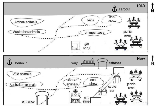
The two diagram illustrate what the changes that took place in how a zoo in australian developed between 1960 and now.
Looking from the map, it is clear that the zoo has witnesses significant changes, the most important of which is the addition of entrance cable car and ferry, the big changes such as small gift shop to floors gift shop, wild animals to Affican animals, etc
Starting at the weast, the harbour was turned into the east of the map, in addition of entrance in the botton of left conner and african animals was converted to wild animals. But only Australian animal wasn’t changed. Next, in the centre of the map, gift shop in the south has enlarged to two floors shop, the appearing of the ferry in the north.
Word Count: 131