Our system will evaluate the answer based on this AI-generated description.
The image contains two maps of an industrial area in the town of Norbiton, showing the current layout and planned future development. The first map depicts the area as it is now, with a river running horizontally across the top, farmland to the north of the river, and a main road labeled as "Town | | Sea" running vertically down the middle. To the east of the road, there are five rectangular industrial buildings arranged in a row, and to the west of the road, there is a larger, circular building labeled as "Factory." In the second map, the future development plan shows the river and farmland in the same positions, but the industrial buildings have been replaced by a circular arrangement of five buildings around a central roundabout, with an additional building to the east. The factory remains in the same location, but there is now a "Playground" to its west, and a residential area labeled as "Housing" has been added to the southwest corner of the map. The road labeled "Town | | Sea" is still present, but it now curves around the new building arrangement.
Given the complexity of the image, the above description may not be entirely accurate.
Skyrocket your IELTS band score by 1-2 points in under a month with our premium plan!
Note: Both the topic and the answer were created by one of our users.
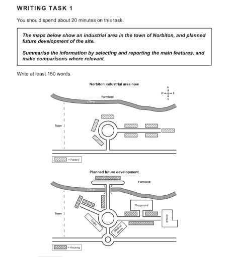
The map illustrates an industrial area in the town of Norbiton, and show future increasing.
Overall, nowadays, map have few factories and farm, and looking significantly poor. However, in the future development map illustrate pretty good, and will have significant development in construction: housing, school, playground, shops and medical center.
Norbiton industrial area now in the east have more factory than in the west part of city, following by in the north part of Norbiton located river and farmland. Overall, in the map located 8 factories, river and farmland.
The second map illustrate future development in this area. In the north will be build the bridge that leads to long housing and river. In east part of map will be school, playground and tow housing near that building and one housing will locate opposite of playground. Near the central roundabout in the south-east will be medical center and, in the south-west, will be shops. In the north-west side will be road that go on two housing. In addition, in the future will be more gorgeous infrastructure and buildings.
Word Count: 178
