Our system will evaluate the answer based on this AI-generated description.
The image provides two diagrams: one illustrating the current state of the Norbiton industrial area, and the other showing the planned future development of the same area. In the current state, the diagram shows the industrial area composed primarily of factories, located to the north of a town (deemed "Town" in the diagram), and adjacent to farmland stretching towards the east. In the future development plan, the industrial area appears to be undergoing transformation with the addition of housing to the west of the factories, a playground to the north, surrounded by additional housing, and the farmland remaining largely untouched. The road system in both diagrams displays a roundabout with a single road branching directly from it towards the east, with the road labeled [20'9"']. Both diagrams orient Northwards and employ conventional map symbols: solid rectangles to denote factories, grid patterns for housing, and dotted outline to indicate a playground, with the remaining area assumed to represent farmland. No numerical data points, percentages, or specific quantitative measures aside from the road label "[20'9"] are provided.
Given the complexity of the image, the above description may not be entirely accurate.
Skyrocket your IELTS band score by 1-2 points in under a month with our premium plan!
Note: Both the topic and the answer were created by one of our users.
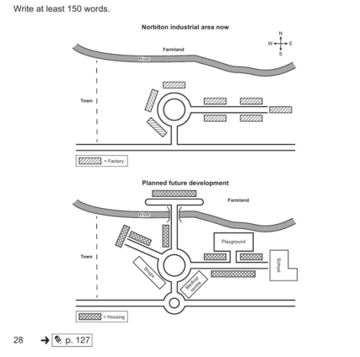
The map describes the current status of an Industrial area in Norbiton and also shows the future proposed development plan.
Overall, the future plan includes converting the whole industrial area into a newly developed residential area with all necessary amenities.
At current the Norbiton industrial area has a circular path which is extended long in eastward direction along with the path there are number of factories itself. And at the northern side there is a farmland towards south there is a road.
The future proposed plan has no factory in it, all the industrial area is set to convert into a residential area with newly added facalities for residents. At the bottom there is a long roadway with a round shape at the center which has path towards the city. Further there will be another circular road which will have medical center at the south-east part and a shop at south-west corner. The road are extended towards the western part which takes towards the housing part and at the eastern section there will be school at the end and playgorund before the school. Through the circular road there is a way which will take to a bypass above the farmland and there is the last housing.
Word Count: 206