Our system will evaluate the answer based on this AI-generated description.
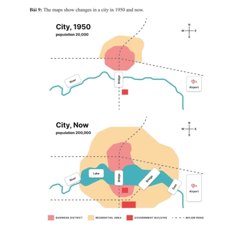
The image shows two city maps labeled "City, 1950" and "City, Now." In 1950, the city's population was 20,000; the map features a business district, a bridge crossing a river, a residential area directly northeast of the business district, a government building to the southwest, and a major road running southeast-northwest; there is also an airport to the southeast. In the current map, the city's population has grown to 200,000; a lake is introduced to the west of the river, with a significantly expanded residential area covering the northeastern part beyond the former borders, enveloping more space to the north and northwest; the southeast airport remains unchanged in location, and the business district remains centrally located adjacent to the river and bridge; the government building stays in its original position, but an additional major road stretches directly north-south intersecting the city.
Given the complexity of the image, the above description may not be entirely accurate.
Skyrocket your IELTS band score by 1-2 points in under a month with our premium plan!
Note: Both the topic and the answer were created by one of our users.
The map illustrate the transformation of a city between 1950 and present.
Overall, it is clear that the city has been witnessed significant changes .Providing natural space ,while expending business and residential areas.
In the centre, it can be seen business and residential have been extended dramatically than in the past.These roads and bridge have been remained unchanged .Similarly,the airpot in the southeast has been stayed intacted but it has been upgraded in to larger.
Since 1950,the river has been transformed into lake and dam in the centre area.While the old government building has been remained unchanged, the new one has been built in the south.Moreover, the road has been opened to new bridge aross the lake .
Word Count: 118