24 Hours Only: Get 39% OFF on Our Premium Plan - Check Out Now!
Map

Band 5+: The maps below show the centre of a small town called Islip as it is now, and plans for is development.

Image for topic: The maps below show the centre of a small town called Islip as it is now, and plans for is development.
Our system will evaluate the answer based on this AI-generated description.
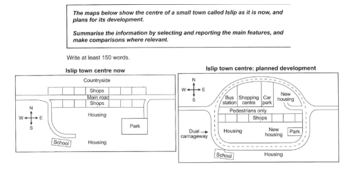
The image contains two maps, "Islip town centre now" and "Islip town centre: planned development", both with a compass rose indicating North. The "now" map shows a central Main road running east-west, lined with Shops on both its north and south sides. North of the shops is Countryside. South of the road is Housing, with a School in the southwest and a Park in the southeast. The "planned development" map shows a large, circular Dual carriageway replacing the Main road. The central area within this road is designated "Pedestrians only" and contains the original south-side Shops. North of the pedestrian area, inside the carriageway, are a Bus station, Shopping centre, Car park, and New housing. South of the pedestrian area, also inside the carriageway, are existing Housing, New housing, and the Park. The School and another area of Housing are located south of the dual carriageway.
Given the complexity of the image, the above description may not be entirely accurate.
Note: Both the topic and the answer were created by one of our users.

The two maps illustrate a center of a small city called Islip in the present and the arrangement for its development.

Overall, the plan they have put in place will make Islip more develop with new facilities add or exsiting ones , such as new housing , car park , bus station, and shopping center .

In The northern part of the Islip town center in this moment , there is country side and two shops with the main road running through them in the middle , moving to the south there is a short way leading to a school , besides to a little park in the eastern corner , and two housing in the midpoint.

Although, in the new strategies of the city, there is a big Dual Carringway, encampass the town , In the north there is new bus station, car park , new housing , one shopping center and many shops , the main read transform into road for spedselnans only , but the easiest park stay as it is in the corner ,back to the south the school became out of the circle .

Word Count: 189

Answers On The Same Topic:

The maps below show the centre of a small town called Islip as it is now, and plans for is development.

The blueprint below shows the current state of Islip’s town centre and the future plan for it’s major enchantment, both maps are completed with pictures and labels. Overall, Islip’s town centre is planning to be developed and renewed to accommodate more locals and visitors. There are a couple of big difference in land use, where […]

The maps below show the centre of a small town called Islip as it is now, and plans for is development.

The two pictures depict how the transfermation of the Islip town centre now and the period when have the planned development. Overall, the area of the town will shift from the small – scale center into a bigger and more modern center after redevelopment and reconstruct plan. The key changes include the appearance of new […]

The maps below show the centre of a small town called Islip as it is now, and plans for is development.

The following are two maps that show the signigicant plans that have occured in centre of Islip town and planned development. Overall, the town has become more urbanized with improved transposrt and entertaiment facilities. The area of countryside has been demolished to make way for new dual carriageway in the plan. On the south side […]

The maps below show the centre of a small town called Islip as it is now, and plans for is development.

The gievn maps illustrates the underwent of the Islip town centre. Overall, Te town centre significantly modernized with better shopping, new housings, and bus station. In particularly, the the urban develoment proceed with Dual carriageway which accounting central areas of the town. There is countryside area now, yet it completely demolished in the planning to […]

See All

Other Topics:

Task 1: The maps below show part of a village in 1910, and the same part of that village in 2010. Summarize the information by selecting and reporting the main features, and make comparisons where relevant.

The two maps illustrate how Shalton Village changed in 2010 compared to 1910 layout. Overall, the village underwent significant transformation, with new housing and amenities being built partially at expense of the green zone. As for the central part of village, where the most substantial changes had occured by 2010, School Road, London Road and […]

The maps below show changes in a rural area between 1970 and 2010.

The maps demonstrates that the main alterations that have been occurred in rural area from 1970 till 2010. Overall, it is clearly seen that, the rural area was developed over the 40 years, new buildings are erected such as football pitch. In 1970, there are school is remain same but its size is diminished in […]

The maps below illustrate how Gregory City changed between 1980 and the present. Summarize the information by selecting and reporting the main features, and make comparisons where relevant.

The maps illustrates the changes of George city from 1980 to nowadays. Overall, nothing changed completely. However, the old town, river, traditional market and bridge near traditional market remained unchanged. The school splitted into 2 buildings , and the overall infrastructure was improved. In addition, new facilities such as government office, an art center, and […]

The maps below show the village of Richardson Pike in 1995 and present day.

The maps illustrates the changes in the village of Richardson Pike since 1995 Overall, the farmland, forest park, shops, fish market, and fishing port were completely transformed, japas Street, Seaview Road, the hotel, and the café stayed unchanged, housing areas were expanded in both the northwest and central parts of the village, a parking near […]

The map below show the changes that have taken place at the seaside resort of Templeton between 1990 and 2005

The map below indicates the differences that have occured in the sea corner park of Templeton in the year 1990 and 2005. On the first hand, In 1990 the town was divided by a river running north to south, with a main road crossing it via a bridge from west to east. Considering the west […]

The diagrams show a small museum and its surroundings in 1990 and 2010. Summarize the information by selecting and reporting the main features and make comparisons where relevant.

The diagram compares a museum and its surroundings between the year 1990 and 2010. There are small amount of changes over the year of time. Overall, the museum is almost as same as before in 1990 but has slighlty been renovated. In 2010 Car park sized has been increased compared to 1990 and also the […]

See All
We have detected unusual activity on your device.
Please verify your identity to continue.
Note: This verification step won't sign you in. If you have a premium account, please log in to access the service as usual.
Google/Gmail Verification
Or verify using Email/Code
We've sent a verification code to:
youremail@gmail.com (Not your email?)
Enter it below to complete the verification process.
Ensure your email address is correct, your inbox is not full, and you check your spam folder. If no email arrives, consider using an alternative email.
You will need a Premium plan to perform your action!
Note: If you already have a premium account, please log in to access our services as usual.

Plans & Pricing

Our mission is to make quality education accessible and free for everyone.
However, to keep our hardworking team running and this service alive, we genuinely need your support!
By opting for a premium plan, not only do you sustain us in achieving the mission, but you also unlock advanced features to enrich your learning experience.

Free

For learners who aren't pressed for time

What's included on Free
1000+ IELTS Tests & Samples
Instant IELTS Writing Task 1 & 2 Evaluation (2 times/month)
Instant IELTS Speaking Part 1, 2, & 3 Evaluation (5 times/month)
Instant IELTS Writing Task 1 & 2 Essay Generator (2 times/month)
500+ Dictation & Shadowing Exercises
100+ Pronunciation Exercises
Flashcards
Other Advanced Tools

Premium

For those serious about advancing their English proficiency, and for IELTS candidates aspiring to boost their band score by 1-2 points (especially in writing & speaking) in just 30 days or less

What's included on Premium
Save Your IELTS Test Progress
Unlock All Courses & Content
Unlimited AI Conversations
Unlimited AI Writing Enhancement Exercises
Unlimited IELTS Writing Task 1 & 2 Evaluation
Unlimited IELTS Speaking Part 1, 2, & 3 Evaluation
Checked Answers Will Not Be Published
Unlimited IELTS Writing Task 1 & 2 Essay Generator
Unlimited IELTS Speaking Part 1, 2, & 3 Sample Generator
Unlimited Usage Of Advanced Tools

Due to the nature of our service and the provided free trials, payments are non-refundable.
Nếu bạn là người Việt Nam và không có hoặc không muốn trả bằng credit/debit cards, bạn có thể thanh toán bằng phương thức chuyển khoản:


Chọn gói:
279,000₫ 157,000 ₫ cho gói 1 tháng (chỉ 5,233₫/ngày)
819,000₫ 397,000 ₫ cho gói 3 tháng (chỉ 4,411₫/ngày)
1,649,000₫ 667,000 ₫ cho gói 6 tháng (chỉ 3,706₫/ngày)
3,299,000₫ 857,000 ₫ cho gói 12 tháng (chỉ 2,381₫/ngày)


Sau khi chuyển khoản, vui lòng đợi trình duyệt tự động điều hướng bạn trở lại Engnovate và bạn sẽ ngay lập tức nhận được mã kích hoạt tài khoản premium.
Nếu có lỗi xảy ra, bạn có thể liên hệ với team thông qua một trong các phương thức: email đến helloengnovate@gmail.com hoặc nhắn tin qua facebook.com/engnovate.
Vì toàn bộ công cụ trên website đều có thể sử dụng thử miễn phí, Engnovate không hỗ trợ hoàn tiền.