🔥 Today Only: Save 30% on Premium — Offer Ends Soon! - Upgrade Now!
Map

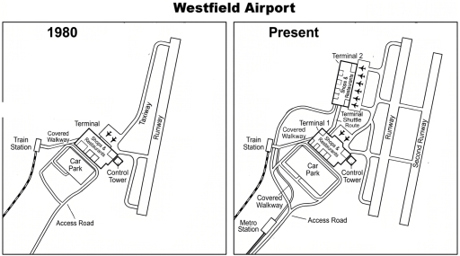
Band 6+: The maps below show the changes that have taken place at Westfield Airport between 1980 and the present day.

Image for topic: The maps below show the changes that have taken place at Westfield Airport between 1980 and the present day.
Our system will evaluate the answer based on this AI-generated description.
The image features two map diagrams titled "Westfield Airport" depicting layouts for "1980" and "Present". The 1980 layout includes a "Train Station" connected via a "Covered Walkway" to a single "Terminal" containing "Shops & Restaurants", an adjacent "Control Tower", 2 airplane icons, an "Access Road" leading to a "Car Park", a "Taxiway", and a single "Runway". In the Present layout, the original terminal is labeled "Terminal 1" (containing "Shops & Restaurants", the "Control Tower", and 2 airplane icons) and is connected via a "Terminal Shuttle Route" to a newly added "Terminal 2" containing "Shops & Restaurants" and 6 airplane icons. Transportation additions include a new "Metro Station" at the bottom left, an expanded "Covered Walkway" network connecting the Train Station, Metro Station, Car Park, Terminal 1, and Terminal 2 along the "Access Road", while runway infrastructure expands to include the original "Runway" alongside a newly added "Second Runway" parallel to it.
Given the complexity of the image, the above description may not be entirely accurate.
Note: Both the topic and the answer were created by one of our users.

The illustrations compare Westfield Airport in 1980 and in the present.

Overall, the airport underwent drastic alternation as the area has been expanded through additional buldings and details as well as repurposing and removing, eventhough the previous layout remained untouched.

In 1980, the place appeared to be a modest airport with a sole terminal located outside a shops & restaurant area and connected with a train station by a covered walkway, alongside a carpark to the west and a single control tower to the east. There was also a taxiway paralleld with a the terminal’s runway.

Nowadays, despite solely having one train platform, another terminal has been added in the north as a replacement for the previous taxi route, and a terminal shuffle route for connection. Covered walkway is simultaneously lengthened and leads to the newly bult metro station. Additionally, a second runaway has been introduced. Although the alternation has significant impacts on the structure, the airport is entered through the same way.

Word Count: 163

Answers On The Same Topic:

The maps below show the changes that have taken place at Westfield Airport between 1980 and the present day.

The maps illustrate the changes that have taken place at Westfield Airport between 1980 and the present day. Overall, the airport has become more modren and expeanded. In 1980, Westfield Airport had just one terminal and shops and restaurants in the center. Below them, there was a covered walkway, and a car park below it. […]

The maps below show the changes that have taken place at Westfield Airport between 1980 and the present day.

The maps compare Westfield Airport in 1980 and the present day, illustrating the changes. Overall, the most noticeable feature is the increase in the number and size of the main facilities. Accessibility has also been improved, as shown by the growth in the number of roads and modes of transportation. The location of the main […]

The maps below show the changes that have taken place at Westfield Airport between 1980 and the present day.

The two maps illustrate the changes that have occurred at Westfield Airport between 1980 and the present day. Overall, extensive changes has occurred over the years, with more infrastructure added, a car park expansion, as well as an additional travel method to arrive at the airport. In the year 1980, the airport only consisted of […]

See All

Other Topics:

The maps below show recent archaeological findings at a historic site in 2004 and 2014. Provide an overview of the information by identifying and describing the key details, and include comparisons where appropriate.

The maps illustrate how recent archaeological discoveries at a historic site changed between 2004 and 2014 . Overall , what is most striking when looking at the maps is that the area underwent a substantial transformation, primarily characterized by the excavation and uncovering of several ancient structures and public facilities. Meanwhile, the original woodland was […]

The maps below show the changes that have occured in Grange Park from 1920 to today

The maps show the changes that have taken place in Grange Park from 1920 to today. Overall, the park has undergone substantial modernisation, with several of its original features being removed or replaced by more recreational facilities, most notably a children’s play area, a cafe and a large concert amphitheatre. In addition, the arrangement of […]

The Map show the South wing of Walton museum in 2008 and in 2012 after redevelopment

The plans illustrate the South Wing of Walton Museum in 2008 and its redevelopment in 2012. Overall, the south wing of Walton Museum underwent significant changes. Some places were expanded, while others completely changed their function and new facilities were added. The special exhibition room remained in the same location, while a terrace was added […]

The diagram shows how Liverton Docks have changed since 1980. Summarise the information by selecting and reporting the main features, and make comparison where relevant.

The maps illustrate how Liverton docks have transformed since 1980 until now. Looking from an overall perspective, it is readily apparent that this area has become more residential, with the emergence of an education center, a kid’s playground, and apartments. There used to be ships operating on this river, but now only a ship museum […]

The diagram shows how Liverton Docks have changed since 1980. Summarise the information by selecting and reporting the main features, and make comparison where relevant.

The diagram illustrates the transformation of Liverton docks from 1980 to the present day. Overall, the area has undergone significant redevelopment, converting what was once an industrial zone into a dynamic space offering various recreational, educational, and residential facilities on both sides of the river. In the past, the northern bank was home to two […]

The map below shows the development of an area between 1995 and the present. Summarize the information by selecting and reporting the main features and make comparisons where relevant.

The maps illustrate the alterations that took place between 1995 and the present. Overall, the area underwent several dramatic changes. Among them, the most important developments are the introduction of recreational facilities and the addition of accommodation facilities to improve accessibility within the area. The northwest of the area saw a number of changes, with […]

See All
We have detected unusual activity on your device.
Please verify your identity to continue.
Note: This verification step won't sign you in. If you have a premium account, please log in to access the service as usual.
Google/Gmail Verification
Or verify using Email/Code
We've sent a verification code to:
youremail@gmail.com (Not your email?)
Enter it below to complete the verification process.
Ensure your email address is correct, your inbox is not full, and you check your spam folder. If no email arrives, consider using an alternative email.
You will need a Premium plan to perform your action!
Note: If you already have a premium account, please log in to access our services as usual.

Plans & Pricing

Our mission is to make quality education accessible for everyone.
However, to keep our hardworking team running and this service alive, we genuinely need your support!
By opting for a premium plan, not only do you sustain us in achieving the mission, but you also unlock advanced features to enrich your learning experience.

Free

For learners who aren't pressed for time

What's included on Free
100+ Cambridge IELTS Tests
Instant IELTS Writing Task 1 & 2 Evaluation (2 times/month)
Instant IELTS Speaking Part 1, 2, & 3 Evaluation (2 times/month)
Instant IELTS Writing Task 1 & 2 Essay Generator (2 times/month)
500+ Dictation & Shadowing Exercises
100+ Pronunciation Exercises
Flashcards
Other Advanced Tools

Premium

For those serious about advancing their English proficiency, and for IELTS candidates aspiring to boost their band score by 1-2 points (especially in writing & speaking) in just 30 days or less

What's included on Premium
Save Your IELTS Test Progress & Analyze Mistakes By Question Type
Save Your Own Flashcard Sets & Use Them On Any Device
Unlock All Courses, IELTS Tests, Section & Part Practice
Unlimited AI Conversations
Unlimited AI Writing Enhancement Exercises
Unlimited IELTS Writing Task 1 & 2 Evaluation
Unlimited IELTS Speaking Part 1, 2, & 3 Evaluation
Checked Answers Will Not Be Published
Unlimited IELTS Writing Task 1 & 2 Essay Generator
Unlimited IELTS Speaking Part 1, 2, & 3 Sample Generator
Unlimited Usage Of Advanced Tools & AI Features
Priority Support within 24h (12-month plan only)

Due to the nature of our service and the provided free trials, payments are non-refundable.