Our system will evaluate the answer based on this AI-generated description.
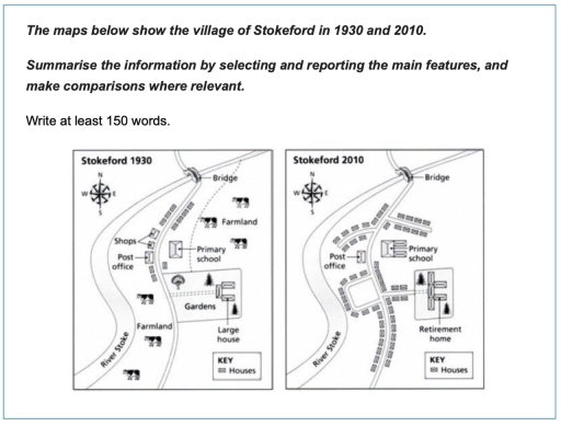
The image is a pair of maps contrasting the village of Stokeford in 1930 and 2010. The 1930 map features a main road traversing from the southwest to northeast, with a bridge over a river. Along this road are shops, a post office, a primary school, and a large house surrounded by farmland. Specifically, five houses are positioned close to the shops, two houses near the post office, and a cluster of six houses next to the primary school. Scattered across the bottom half are four additional houses, identified as farmland residences. Conversely, the 2010 map shows the same main road and bridge but exhibits significant change. The shops have been replaced with a solitary house, while the post office persists. The primary school remains, now neighbored by a retirement home. The farmland has been converted entirely into residential space with thirteen new houses. Across the main road, two more houses have been added next to the existing post-office-adjacent homes, and the cluster previously near the primary school has grown by four more houses. The former large house plot has been redeveloped, featuring five new houses. The previous bottom farmland houses are replaced with a row of six new residences. No farmland is evident in 2010, marking a complete transition from agricultural to residential land use.
Given the complexity of the image, the above description may not be entirely accurate.
Skyrocket your IELTS band score by 1-2 points in under a month with our premium plan!
Note: Both the topic and the answer were created by one of our users.
The given iven map depicts the village of stokeford in 1930 and 2010
It is clear that significant changes are made in the farmland and gardens areas. It can also be seen that there is a massive tranformation near the river stuke.
In place of the farmland and gardens, which were shown in the 1930 map, the current map shows retirement home. In contrast, the post office and primary school have remained the same since 1930, but the gardens and large house turn into retirement home.
By 2010, the post office, bridge, and the primary school remained. The shops, however, were removed, and much of the garden, including many trees Furthermore. thermore, the number of house increased significantly, occupying the dreas previously.
Word Count: 122
