Our system will evaluate the answer based on this AI-generated description.
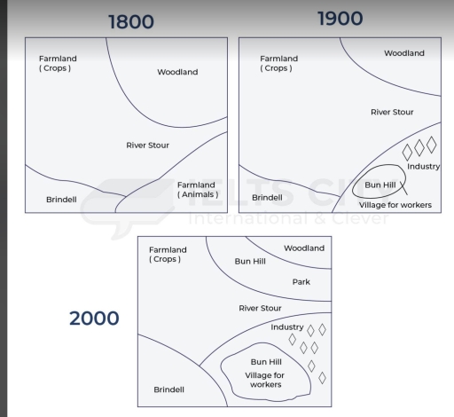
The image contains three maps depicting the layout changes of a region across the years 1800, 1900, and 2000. In 1800, the region includes Farmland (Crops) in the northeast, Woodland in the north, River Stour running horizontally with Farmland (Animals) south of it, and Brindell located in the southwest. In 1900, Farmland (Crops) areas are reduced and shifted to the far east, Woodland occupies less area in the north, River Stour flows as before, and new additions include Industry in the southeast and a Village for Workers with Bun Hill around it in the eastern region. By 2000, Farmland (Crops) remains to the east, Woodland is in a small northern section, a new Park appears adjacent to Woodland, River Stour maintains its path, Industry grows larger in the southeast, the Village for Workers with Bun Hill remains, and Brindell stays in the southwest.
Given the complexity of the image, the above description may not be entirely accurate.
Skyrocket your IELTS band score by 1-2 points in under a month with our premium plan!
Note: Both the topic and the answer were created by one of our users.
The picture demonstrates how an area changed in three years: 1800, 1900 and 2000.
Overall, it is clear that during the period of modernization, the woodland was replaced by parks and Bun Hill. Meanwhile, farmland, which was the largest area, decreased in size.
Regarding the two maps in 1800 and 1900, it can be seen that this area was an agricultural area, which included Farmland, Woodland. In 1800, Farmland consisted of the use for animals and crops. This area for crops was in the north-west of the map and this location did not change during a century. However, the area for animal purpose decreased in size with the appearance of Bun Hill and industrial zone in the right bottom of the side. Additionally, the Brindell was not changed.
In 2000, the map underwent a number of changes. This was the first time that many public facilities were built. The Bun Hill and a village for workers were expanded, therefore the area of industry was increased in size. Similarly, Brindell saw an expansion in the south-west of the map. However, Woodland, farmland used for crops shrank in size. Instead, a park and Bun Hill were built and developed.
Word Count: 197