🔥 Today Only: Save 30% on Premium — Offer Ends Soon! - Upgrade Now!
Map

Band 6+: The plans below show a harbour in 2000 and how it looks know.

Image for topic: The plans below show a harbour in 2000 and how it looks know.
Our system will evaluate the answer based on this AI-generated description.
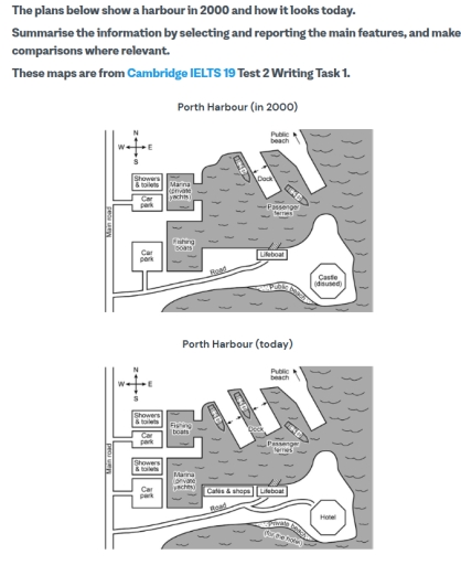
The image depicts two maps of Porth Harbour, one from 2000 and the other representing the current state, detailing the harbor changes: in 2000, a road connects from the southwest to the east with two car parks, a large car park in the west and a smaller car park in the east; a marina with three berths is located north with a fishing berth to its east; passenger, fishing, and cruise ships moving southeast with a lighthouse situated centrally on the eastern land extension; lifeboat present south of the holiday cottages, positioned in the central harbor; near the northeastern shore, a public beach extends northwesterly; currently, the marina expands to accommodate five new yachting berths, while the fishing berth is replaced by four new apartments; the road now includes a café situated north of the holiday park; the east's large car park is now a car control area; previous fishing and cruise passengers areas are now solely for private boats with sailboats added, and the lifeboat area remains unchanged; lighthouse removed and a new hotel occupies its previous location.
Given the complexity of the image, the above description may not be entirely accurate.
Note: Both the topic and the answer were created by one of our users.

The presented map illustrates Porth Harbour as it was in the year 2000 and highlights various transformations that have taken place up to the present day.

Overall, the fact that Porth Harbour has become more reachable for visitors and shifted from being used for commercial purposes to more private and personal use is evident.

In previous years, the northeast area of the harbour featured only one dock located just below the public beach. At present times, the public beach remains in its original location, but a second dock has been added to accommodate passenger ferries. Additionally, on the northwest side of the harbour, the marina for private yachts has been relocated slightly southward, where the fishing boat area once existed. Furthermore, next to the main road, placed to the west part of the harbour, a new shower and toilet facilities were constructed just above the car park, previously connected to the road in the south part of the given area.

In the southeastern corner of the harbour, a disused castle has been rearranged to the hotel, connected to the earlier public beach, which the hotel had now privatised. Moreover, the west wing of the already existing lifeboat, which is still attached to the south road, is now surrounded by cafes and shops.

Word Count: 212

Answers On The Same Topic:

The plans below show a harbour in 2000 and how it looks know.

The maps illustrate Porth Herbour. It provides information about the changes between Porth in 2000 and today. The most noticeable feature is that, there are a lot of new goods standing out. For example a bunch of brand new buildings and some develops for society. By constant, it is incredible rise. By comparison, in 2000 […]

The plans below show a harbour in 2000 and how it looks know.

The given maps illustrate Porth Harbour in the past and the changes that have been made in the present day. Overall, the harbour has witnessed radical transformation. However, the characteristics at the top side of the map mostly remain the same. It can be seen that in the past, there was a single dock in […]

The plans below show a harbour in 2000 and how it looks know.

The plans below illustrate the difference layouts of Porth Harbour, comparing its design in 2000 to its current state. In general, it is clear that the main changes over the 20-year period involve the addition of facilities, adjustments to docks for private yachts and fishing boats, and changes in beach usage. In the southeast corner […]

The plans below show a harbour in 2000 and how it looks know.

The plans below illustrate a harbour in 2000 and how it has transformed nowadays. Overall, it can be seen that after two decades significant modernisation has taken place with several buildings have been built. There were a dock,two passenger ferries and a public beach in the northern part of plan in 2000.Later, a harbour and […]

The plans below show a harbour in 2000 and how it looks know.

The plans illustrate the layouts of Porth Harbour in 2000 and today. Overall, a lot of changes have been made to the harbour for accessibility and convenience. On the west side of the harbour, there’s a main road runs from the north to the south, from which a side road extents towards the harbour on […]

See All

Other Topics:

The plan below show the site of an airport now and how it will look after redevelopment next year. Summarise the information by selecting and reporting the main features and make comparisons where relevant.

The plan describes the how the southwest airport will look after it undergoes development. The current plan, shows a simple look of the current airport with just a few features which will undergo a notable expansion to a modern and more developed look. Below are the highlighted changes that will occur. The number of gates […]

The map below shows the plan of a proposed new town. Summarise the information by selecting and reporting the main features, and make comparison where relevant.

The map shows the idea of constructing a new town. Overall, it is clear that the town has transformed significantly, with the development of several : roads, housing, parking and bus stands. The industry is located in north and in the south corner. There is a ring road in the middle of the town, and […]

The two maps below show a housing estate as it is now and how it will look after redevelopment.

The two maps illustrate the now status and the planning for the future development housing estate Overall, the area is covered by woodland and the housing distribution is sparse while the planning for the house shows that these areas are planning to position the layout of these houses. The forest are clear and replaced by […]

The plans below show the layout of a town called Sholeaton in 1985 and in 2015.

The two maps compare the layout of a town called Sholeaton in 1985 and how it had changed in 2015. Overall, the town had undergone remarkable developments. The most noticeable transformations were in transport infrastructure and commercial facilities. One of the most striking changes was road system. To be more specific, there was the addition […]

The plans below show the site of a farm in 1950 and the same site today. Summarise the information by selecting and reporting the main features, and make comparisons where relevant.

The map illustrates the differences between Beechwood farm in 1950 and how it looks today. Overall, the farm has been modernized by adding newly constructed facilities and improving infrastructure. It is obvious that most of the changes were in the eastern part of the territory. First, there was a sheep field in the north, which […]

The two plans below show a bookstore in 2000 and the bookstore now. Summarise the information by selecting and reporting the main features, and make comparisons where relevant.

The two plans illustrate how much bookshops developed from 2000 to the present. Overall, bookstores have not added any new types of books, but have added Cafe counter and three tables where people can sat and ate their food or just chill and read their book. Also placements of bookshelves have changed. In 2000, store […]

See All
We have detected unusual activity on your device.
Please verify your identity to continue.
Note: This verification step won't sign you in. If you have a premium account, please log in to access the service as usual.
Google/Gmail Verification
Or verify using Email/Code
We've sent a verification code to:
youremail@gmail.com (Not your email?)
Enter it below to complete the verification process.
Ensure your email address is correct, your inbox is not full, and you check your spam folder. If no email arrives, consider using an alternative email.
You will need a Premium plan to perform your action!
Note: If you already have a premium account, please log in to access our services as usual.

Plans & Pricing

Our mission is to make quality education accessible for everyone.
However, to keep our hardworking team running and this service alive, we genuinely need your support!
By opting for a premium plan, not only do you sustain us in achieving the mission, but you also unlock advanced features to enrich your learning experience.

Free

For learners who aren't pressed for time

What's included on Free
100+ Cambridge IELTS Tests
Instant IELTS Writing Task 1 & 2 Evaluation (2 times/month)
Instant IELTS Speaking Part 1, 2, & 3 Evaluation (2 times/month)
Instant IELTS Writing Task 1 & 2 Essay Generator (2 times/month)
500+ Dictation & Shadowing Exercises
100+ Pronunciation Exercises
Flashcards
Other Advanced Tools

Premium

For those serious about advancing their English proficiency, and for IELTS candidates aspiring to boost their band score by 1-2 points (especially in writing & speaking) in just 30 days or less

What's included on Premium
Save Your IELTS Test Progress & Analyze Mistakes By Question Type
Save Your Own Flashcard Sets & Use Them On Any Device
Unlock All Courses, IELTS Tests, Section & Part Practice
Unlimited AI Conversations
Unlimited AI Writing Enhancement Exercises
Unlimited IELTS Writing Task 1 & 2 Evaluation
Unlimited IELTS Speaking Part 1, 2, & 3 Evaluation
Checked Answers Will Not Be Published
Unlimited IELTS Writing Task 1 & 2 Essay Generator
Unlimited IELTS Speaking Part 1, 2, & 3 Sample Generator
Unlimited Usage Of Advanced Tools & AI Features
Priority Support within 24h (12-month plan only)

Due to the nature of our service and the provided free trials, payments are non-refundable.