24 Hours Only: Get 39% OFF on Our Premium Plan - Check Out Now!
Map

Band 6+: The plans below show a harbour in 2000 and how it looks know.

Image for topic: The plans below show a harbour in 2000 and how it looks know.
Our system will evaluate the answer based on this AI-generated description.
The image depicts two maps of Porth Harbour, one from 2000 and the other representing the current state, detailing the harbor changes: in 2000, a road connects from the southwest to the east with two car parks, a large car park in the west and a smaller car park in the east; a marina with three berths is located north with a fishing berth to its east; passenger, fishing, and cruise ships moving southeast with a lighthouse situated centrally on the eastern land extension; lifeboat present south of the holiday cottages, positioned in the central harbor; near the northeastern shore, a public beach extends northwesterly; currently, the marina expands to accommodate five new yachting berths, while the fishing berth is replaced by four new apartments; the road now includes a café situated north of the holiday park; the east's large car park is now a car control area; previous fishing and cruise passengers areas are now solely for private boats with sailboats added, and the lifeboat area remains unchanged; lighthouse removed and a new hotel occupies its previous location.
Given the complexity of the image, the above description may not be entirely accurate.
Note: Both the topic and the answer were created by one of our users.

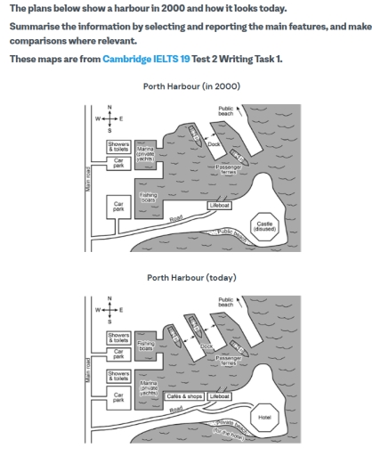
The plans illustrate the layouts of Porth Harbour in 2000 and today.

Overall, a lot of changes have been made to the harbour for accessibility and convenience.

On the west side of the harbour, there’s a main road runs from the north to the south, from which a side road extents towards the harbour on the south side of the harbour. One car park, some showers and toilets are the unchanged features besides the main road. But the car park on the south has switched its entrance from the side road to the main road, accompanied with some new showers and toilets.

On the north-east side of the harbour, one can see the number of docks for passenger ferries increased from one to two. On the west, the areas for fishing boats and for private yachts has exchanged, which means the marina in the south is bigger now. And if one go through the side road from the main road, new cafes and shops can be seen adjament to the lifeboat.

In the south-east corner, the biggest change is that the disused castle has been taken place by a hotel, which has a shorter side road connectd with the former one. At the same time, the public beach has been converted into a private beach for the hotel.

Word Count: 218

Answers On The Same Topic:

The plans below show a harbour in 2000 and how it looks know.

The provided map delineates the transformation of Porth Harbour, as its existed array in 2000 and its current improvement. A comprehensive analysis reveals a significant improvement in its amenities, coupled with the rearrangement some facilities and the addition of a dock. In 2001, the Porth Harbour featured a straightforward arrangement, comprising a dock, a public […]

The plans below show a harbour in 2000 and how it looks know.

The presented maps illustrate changes in Porth Harbour between 2000 and today. Overall, the village has undergone modernization especially, cafes & shops and hotel fields have been added. Marina and Fishing boats experience significant alteration and some roads extending to make way for new establishments. In 2000, the South-east side of the village had a […]

The plans below show a harbour in 2000 and how it looks know.

The given maps illustrate the layout of Porth harbour in 2000 and its current arrangement. Overall, it can be clearly seen that the map has not undergone significant alterations. It has a vertical main road in the west part adjacent to an additional road which goes from the bottom to the centre. As for the […]

The plans below show a harbour in 2000 and how it looks know.

The plans present Porth Harbour 25 years ago and now. Overall, comparing two maps, there are significant changes with additional buildings and facilities, the harbour has become more commercial. Looking at the 2000 harbour, there was only one dock and sole building for showers and toilets. There also used to be unused castle on southeast […]

See All

Other Topics:

The plans below show the South Wing of Walton Museum in 2008 and in 2012 after it was redeveloped.

The plans demonstrate considerable changes of south wing from 2008 to 2012. Overall, the noticeable thing it is size of south wing also some places have not been changes. By 2008, there was single-storey floor and there were five rooms. VISITORS ARRIVED THROUGH A ENTRANCE in order TO REACH a special exhibition room which is […]

The leo maps below illustrate one area with a difference of a hundred years

The two maps below demonstrate the same neighbourhood with a difference of a hundred years. Overall, the area fully transformed from average suburb to urban area. In 1920 it was a rural area, consisting of two groups of houses, while one of them used to have access to the beach. They were located in northeast […]

The maps below show the center of a small town called Islip as it is now, and the plans for its development. Summarise the information by selecting and reporting the main features, and make comparisons where relevant.

The two maps are show use the Islip center of a small town , in the current form and its proposed expansion. Overview , that is clear that plan wants to increase the area of the cenret, add a new stores and spaces to rest and enjoe . Owners want to extend the pedestrans tierritory, […]

The plans below show the site of a farm in 1950 and the same site today. Summarise the information by selecting and reporting the main features, and make comparsons where relevant.

The given maps illustrate the structural development of the beachwood farm from 1950 to this day. Overall, the farm is located to the east of the main road, has surrounded by a river through west to south-eastern part of the map. Over the period, the beachwood farm was completely transformed by adding new features, such […]

The maps below show the town of Barkham in 1990 and 2000. Summarise the information by selecting and reporting the main features, and make comparisons where relevant.

Two distinct map shows the changes that has been taken place in Barkham from 1990 to 2000. Overall, the town has added various facilities for different ranges of age groups which attracts lots of public customers. In 1990, previously there was a farmland which has been replaced by business district while, a shopping centre had […]

The maps below show the changes in the art gallery ground floor in 2015 and present day.

The map compares the layout of the ground floor of an art gallery in 2015 and its current plan. Overall, the art gallery has undergone a significant modernization with the addition of new facilities and the relocation of some facilities. While the main structure of the ground floor has generally remained, the original exhibition room […]

See All
We have detected unusual activity on your device.
Please verify your identity to continue.
Note: This verification step won't sign you in. If you have a premium account, please log in to access the service as usual.
Google/Gmail Verification
Or verify using Email/Code
We've sent a verification code to:
youremail@gmail.com (Not your email?)
Enter it below to complete the verification process.
Ensure your email address is correct, your inbox is not full, and you check your spam folder. If no email arrives, consider using an alternative email.
You will need a Premium plan to perform your action!
Note: If you already have a premium account, please log in to access our services as usual.

Plans & Pricing

Our mission is to make quality education accessible and free for everyone.
However, to keep our hardworking team running and this service alive, we genuinely need your support!
By opting for a premium plan, not only do you sustain us in achieving the mission, but you also unlock advanced features to enrich your learning experience.

Free

For learners who aren't pressed for time

What's included on Free
1000+ IELTS Tests & Samples
Instant IELTS Writing Task 1 & 2 Evaluation (2 times/month)
Instant IELTS Speaking Part 1, 2, & 3 Evaluation (5 times/month)
Instant IELTS Writing Task 1 & 2 Essay Generator (2 times/month)
500+ Dictation & Shadowing Exercises
100+ Pronunciation Exercises
Flashcards
Other Advanced Tools

Premium

For those serious about advancing their English proficiency, and for IELTS candidates aspiring to boost their band score by 1-2 points (especially in writing & speaking) in just 30 days or less

What's included on Premium
Save Your IELTS Test Progress
Unlock All Courses & Content
Unlimited AI Conversations
Unlimited AI Writing Enhancement Exercises
Unlimited IELTS Writing Task 1 & 2 Evaluation
Unlimited IELTS Speaking Part 1, 2, & 3 Evaluation
Checked Answers Will Not Be Published
Unlimited IELTS Writing Task 1 & 2 Essay Generator
Unlimited IELTS Speaking Part 1, 2, & 3 Sample Generator
Unlimited Usage Of Advanced Tools

Due to the nature of our service and the provided free trials, payments are non-refundable.
Nếu bạn là người Việt Nam và không có hoặc không muốn trả bằng credit/debit cards, bạn có thể thanh toán bằng phương thức chuyển khoản:


Chọn gói:
279,000₫ 157,000 ₫ cho gói 1 tháng (chỉ 5,233₫/ngày)
819,000₫ 397,000 ₫ cho gói 3 tháng (chỉ 4,411₫/ngày)
1,649,000₫ 667,000 ₫ cho gói 6 tháng (chỉ 3,706₫/ngày)
3,299,000₫ 857,000 ₫ cho gói 12 tháng (chỉ 2,381₫/ngày)


Sau khi chuyển khoản, vui lòng đợi trình duyệt tự động điều hướng bạn trở lại Engnovate và bạn sẽ ngay lập tức nhận được mã kích hoạt tài khoản premium.
Nếu có lỗi xảy ra, bạn có thể liên hệ với team thông qua một trong các phương thức: email đến helloengnovate@gmail.com hoặc nhắn tin qua facebook.com/engnovate.
Vì toàn bộ công cụ trên website đều có thể sử dụng thử miễn phí, Engnovate không hỗ trợ hoàn tiền.