🔥 Today Only: Save 30% on Premium — Offer Ends Soon! - Upgrade Now!
Map

Band 6+: The plans below show a harbour in 2000 and how it looks today.

Image for topic: The plans below show a harbour in 2000 and how it looks today.
Our system will evaluate the answer based on this AI-generated description.
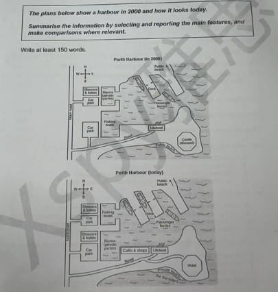
The image presents two maps of Porth Harbour; the 2000 map shows a seawall on the west, a cranes area to the north of the seawall, and a warehouse positioned east of the cranes. East of the warehouse is a café; north of the café is a fishing area; northeast of the café is a boat yard; southeast is a dockyard; directly east is a fishing area; and south is a car park area with a main road extending from north to south connecting all main structures, leading to a lighthouse to the northeast of the car park. The current map introduces sailing clubs replacing the cranes and boat yard, the former warehouse converted to apartments, the fishing area near the apartments also replaced with another sailing club. The café and east fishing area remain unchanged, but to the north of the road (and east of the main road) new establishments (cafés, shops) are present along with a new footpath extending from the main road to the lighthouse.
Given the complexity of the image, the above description may not be entirely accurate.
Note: Both the topic and the answer were created by one of our users.

The maps here illustrate the layout of Porth harbor in 2000 at its current state.

This site contains facilities and infrastructures that have been used for entertainment purposes. The major changes in this location are increasing the number of docks and adding a hotel, some cafes, and shops.

There are two roads in this site that links the main facilities. The main road that goes along the harbor from south to north and a branch of this road that goes to east connecting the main road to the hotel where a disused hotel was located in 2000. This road also provides easy access to newly built cafes and shops near the lifeboat. The beach in this part of the harbor used to be public, but now it is a private area belonging to the hotel.

In the vicinity of the main road the were 2 car parks and one location for showers and toilets in 2000. These areas are still in the same location but an additional room for showers and toilets is constructed. harbor itself experienced some changes as well. the sites dedicated for fishing boats and private yachts were replaced by one another. And an extra dock is built near the previous one in the north.

Word Count: 208

Answers On The Same Topic:

The plans below show a harbour in 2000 and how it looks today.

The provided plans illustrate how Porth Harbour has changed from 2000 to now. Overall, the port has become more developed over the period, with several new buildings constructed and some empty areas replaced by new modern facilities. In the southwest corner, the new road layout was reorganised leading to the car park. Moving southward, in […]

The plans below show a harbour in 2000 and how it looks today.

The two maps illustrate the development of a harbour between 2000 and today. Overall, the area has been significantly modernised, with major changes in infrastructure, land use, and tourist facilities. In 2000, the harbour was mainly an industrial zone, dominated by warehouses, a small cargo dock, and limited road access. The coastline was largely unused, […]

The plans below show a harbour in 2000 and how it looks today.

The two maps illustrate how Porth Harbour has changed between 2000 and the present day. Overall, the harbour has undergone a significant transformation from a largely functional, fishing-based facility into a more modern, tourist-oriented destination. This shift is marked by the addition of several leisure-related amenities – such as cafés, shops, a hotel and a […]

The plans below show a harbour in 2000 and how it looks today.

The provided maps illustrate the architectural changes in Porth Harbour between 2000 and the present. Overall, the maps indicate that Porth Harbour’s infrastructure underwent significant changes due to development. Compared to the maps, in 2000 there was one dock and two passenger ferries at the public beach. Today, a dock and a passenger ferry have […]

The plans below show a harbour in 2000 and how it looks today.

The two maps illustrate the development plans for Porth Harbour from 2000 to the present day. Overall, several new land-based facilities have been constructed, including a hotel, cafes, shops, and restrooms. Additionally, the locations of the marine and fishing boat ports have been swapped, and a new dock has been built. In 2000, there were […]

See All

Other Topics:

The maps below compare the town of Brindell and local areas in 1800, 1900 and 2000. Summarise the information by selecting and reporting the main features, and make comparisons where relevant.

The three maps illustrate changes to the town of Brindell and its surrounding areas in 1800, 1900 and 2000. Overall, the farmland was transformed into Bun Hill Park, and villages were built for workers to live in. A part of the River Stour was converted into a new Bun hill park which was erected in […]

The maps show how a public building changed over different periods of time.

The three maps illustrate the development of a public building in three periods of time. Overall, the building has undergone dramatic changes, the most important of which is the redesign of functional areas, transforming from the history reading room into the meeting room and then converting into the theatre in the present. In the first […]

The diagrams below show the present building of a college and the plan for changes to the college site in the future.

The given layouts demonstrate how college site is planned to have changed in the upcoming in 2020.Although the initial map was predominantly undeveloped,the after map reveals reception,toilet and footpath,and some places remained unchanged such as bus stop. The road to the south of the plan was kept on the same place and north of the […]

The two maps below show a housing estate now,and how it will look after redevelopment

The two maps given illustrate how a housing estate currently looks and how it will be redeveloped in the future. Overall, the housing estate is set to undergo significant changes and development in its structure, with the most notable being the construction of new residential areas, sports facilities. Additionally, much of the central green space […]

The diagrams show how a district park looked ten years ago and how it looks now .

The map illustrates the changes in a district park over 10 years from 2004 to 2014. Overall, the park experienced a number of significant changes, the most important of which were the addition of recreational facilities, especially cycling path surrounding the whole park, along with the expansion of car park and children playcare. Looking first […]

The maps below show the changes that have taken place at Forton Valley City from 2000 to 2010. Summarize the information by selecting and reporting the main features and make comparisons where relevant.

The diagrams illustrates how Forton Valley City changed after some developments between 2000 and 2010 Overall as can be inferred from the geven maps, the surveyed areas had undergone many dramatic changes, with the underlying purpose of serving the educational needs of local people. It both 2000 and 2010 shopping center ocoppy a large areas […]

See All
We have detected unusual activity on your device.
Please verify your identity to continue.
Note: This verification step won't sign you in. If you have a premium account, please log in to access the service as usual.
Google/Gmail Verification
Or verify using Email/Code
We've sent a verification code to:
youremail@gmail.com (Not your email?)
Enter it below to complete the verification process.
Ensure your email address is correct, your inbox is not full, and you check your spam folder. If no email arrives, consider using an alternative email.
You will need a Premium plan to perform your action!
Note: If you already have a premium account, please log in to access our services as usual.

Plans & Pricing

Our mission is to make quality education accessible for everyone.
However, to keep our hardworking team running and this service alive, we genuinely need your support!
By opting for a premium plan, not only do you sustain us in achieving the mission, but you also unlock advanced features to enrich your learning experience.

Free

For learners who aren't pressed for time

What's included on Free
100+ Cambridge IELTS Tests
Instant IELTS Writing Task 1 & 2 Evaluation (2 times/month)
Instant IELTS Speaking Part 1, 2, & 3 Evaluation (2 times/month)
Instant IELTS Writing Task 1 & 2 Essay Generator (2 times/month)
500+ Dictation & Shadowing Exercises
100+ Pronunciation Exercises
Flashcards
Other Advanced Tools

Premium

For those serious about advancing their English proficiency, and for IELTS candidates aspiring to boost their band score by 1-2 points (especially in writing & speaking) in just 30 days or less

What's included on Premium
Save Your IELTS Test Progress & Analyze Mistakes By Question Type
Save Your Own Flashcard Sets & Use Them On Any Device
Unlock All Courses, IELTS Tests, Section & Part Practice
Unlimited AI Conversations
Unlimited AI Writing Enhancement Exercises
Unlimited IELTS Writing Task 1 & 2 Evaluation
Unlimited IELTS Speaking Part 1, 2, & 3 Evaluation
Checked Answers Will Not Be Published
Unlimited IELTS Writing Task 1 & 2 Essay Generator
Unlimited IELTS Speaking Part 1, 2, & 3 Sample Generator
Unlimited Usage Of Advanced Tools & AI Features
Priority Support within 24h (12-month plan only)

Due to the nature of our service and the provided free trials, payments are non-refundable.