Our system will evaluate the answer based on this AI-generated description.
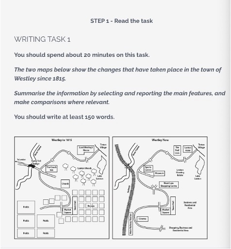
The image compares two maps illustrating changes in the town of Westley between 1815 and the present. In 1815, Westley features a river flowing from north to south with a bridge towards the north. To the west of the river lies a residential area with multiple individual houses. To the east, beside the bridge, is a factory. To the southeast are fields surrounding a central square. In the current map, the residential area has transformed into a large housing estate. The factory is replaced by a business park. A leisure center appears north of the housing, adjacent to a newly developed golf course and parkland replacing fields. The road infrastructure includes a network connecting these areas. An additional bridge has been constructed south of the original. The central square now hosts a shopping, business, and leisure complex. The river remains but with landscaped surroundings, and one field area persists unchanged in the southwest.
Given the complexity of the image, the above description may not be entirely accurate.
Skyrocket your IELTS band score by 1-2 points in under a month with our premium plan!
Note: Both the topic and the answer were created by one of our users.
The given maps illustrate information regarding the main alterations which have occurred in a particular town named Westley during a 110-year period from 1815 to 2024.
Overall, what stands out from the maps is that the whole town has become much more modernised, with more entertainment and business facilities being erected, but fewer green areas.
Looking from a detailed perspective, the Lenton Woods in the northeast of the town have been removed, and a new Lenton Housing Estate has been constructed. To the south of it, the original housing area has been demolished to make way for a business and residential area, with only the Market Square and Town Hall remained.
If we look at the west side of town, there was a Twin Toll Bridge over the river and five blocks of fields at the southwest corner of the town. However, they all have been knocked down and a railway has been built to cross the river and connect it to the southwest corner where a railway station stands now. To the east of the railway station, this area has been occupied by a shopping area as well as business and residential functions.
Word Count: 194
