Our system will evaluate the answer based on this AI-generated description.
The image shows two maps comparing a park in Canada between the years 1995 and 2015, focusing on several features: In 1995, the park provides a campsite (A) to the south of the river and waterfall, located near the marina along a lake, and a parking area (P) situated slightly southeast. A designated information point is positioned northeast in relation to the waterfall, whereas, in 2015, adjustments include the addition of a cafe directly northeast of the waterfall, a shuttle bus route and stop extending along and parallel to walking/biking trails leading from the parking area (P) towards the marina, and coexisting with the campsite and waterfall area from 1995, seen without change; the mentioned lake, marina, information point, and parking area maintain their locations as in 1995 but now function amid expanded additional trails and shuttle infrastructure, illustrating modifications to the original layout by 2015.
Given the complexity of the image, the above description may not be entirely accurate.
Skyrocket your IELTS band score by 1-2 points in under a month with our premium plan!
Note: Both the topic and the answer were created by one of our users.
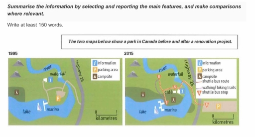
The two visuals detail the changes since 1995 to 2015 of a Canadian park.
Overall, it is evident that the park underwent many changes during renovation project. It is seen from the pictures that several areas of the park were expanded and multiple relocations happened.
Since 1995, both parking and camping zones were extended. The campsite was stretched alongside the coast and a part was added to the opposite side of the lake. The marina located on this lake was supplemented with small flanges. Parking area was enlarged by about 4 times and was moved further from the center of the park to the right side of the Highway 25. A relocation of the information desk can be also noticed. It was relocated nearer to the entrance of the park.
At the same time, new roads were added. In 2015, the shuttle bus route began to connect parking area with the central zone. It had four stops, three of which were located next to the main areas of the park. Visitors could also get by bus to the cafe, which was built near the entrance. Moreover, the marina and waterfall were connected through walking and biking trails.
Word Count: 197