Our system will evaluate the answer based on this AI-generated description.
The image contains two maps labeled "Norbiton industrial area now" and "Planned future development." The first map shows an area with a road running vertically connected to a horizontal road with 'Town 1' to the left and 'Farmland' to the right; below, a Factory is indicated near the meeting point of the roads. The compass on the top right points North upwards, East to the right, South downwards, and West to the left. The second map illustrates a more developed area with additional roads branching out from the central meeting point, forming a circular pattern with intersections. It shows 'Town 1' still to the left, 'Farmland' to the right, and the 'Factory' in the same place near the center. Additions include 'Housing' indicated on three of the new road branches and two 'Playground' areas on the remaining new road branches. Both maps use the same compass orientation. The bottom of the image includes the number "28" and an arrow pointing right to "p. 127." No other numerical data points/percentages or additional information are visible.
Given the complexity of the image, the above description may not be entirely accurate.
Skyrocket your IELTS band score by 1-2 points in under a month with our premium plan!
Note: Both the topic and the answer were created by one of our users.
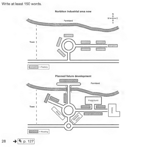
The two diagrams of maps represent that currently area is using for factories in Norbiton, in future it has been going to converted to resedential area.
Overall, It is clearlly mention that the boundry for the future plan remain same. However,all the industries area is going to converted into housing societies.
On the north side has to be develop houses across the river furthermore it will going to connect the road from the middle main roundabout.At present farmland has huge area but in future it will be shifting towards north east side.
Future Norbiton plan will get all the basic needs on this area like school, playground, medical center and shops for residence. all the roads are connect to each other. As a result housing will be going to spread all over the plan.However, one more round about will be added in future plan to connect the main road.
Word Count: 149
