Our system will evaluate the answer based on this AI-generated description.
The image depicts two maps of Porth Harbour, one from 2000 and the other representing the current state, detailing the harbor changes: in 2000, a road connects from the southwest to the east with two car parks, a large car park in the west and a smaller car park in the east; a marina with three berths is located north with a fishing berth to its east; passenger, fishing, and cruise ships moving southeast with a lighthouse situated centrally on the eastern land extension; lifeboat present south of the holiday cottages, positioned in the central harbor; near the northeastern shore, a public beach extends northwesterly; currently, the marina expands to accommodate five new yachting berths, while the fishing berth is replaced by four new apartments; the road now includes a café situated north of the holiday park; the east's large car park is now a car control area; previous fishing and cruise passengers areas are now solely for private boats with sailboats added, and the lifeboat area remains unchanged; lighthouse removed and a new hotel occupies its previous location.
Given the complexity of the image, the above description may not be entirely accurate.
Skyrocket your IELTS band score by 1-2 points in under a month with our premium plan!
Note: Both the topic and the answer were created by one of our users.
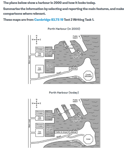
The plans below illustrate the difference layouts of Porth Harbour, comparing its design in 2000 to its current state.
In general, it is clear that the main changes over the 20-year period involve the addition of facilities, adjustments to docks for private yachts and fishing boats, and changes in beach usage.
In the southeast corner of the harbour, a hotel was built to replace the disused castle, and the beach to the west of it was accordingly converted from public beach to private beach just for the hotel guests. Meantime, some cafes and shops were open next to the Lifeboat. On the west near the dock, the marina for private yachts replaced the docks for fishing boats, while the fishing boats were relocated to the former location of the marina. Additionally, some showers and toilets were constructed between two car parks along the main road.
The northern half of the plans remained largely unchanged, except for the addition of a new dock,which largely expand the capacity. The public beach to the north of the docks saw no change over the 20 years, remaining at the far east of the harbour.
Word Count: 190